
Carte topographique Chiusa di Pesio
Carte interactive
Cliquez sur la carte pour afficher l’altitude.
À propos de cette carte
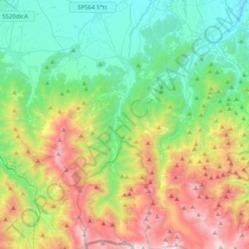
Nom : Carte topographique Chiusa di Pesio, altitude, relief.
Lieu : Chiusa di Pesio, Cuneo, Piedmont, 12013, Italy (44.17360 7.60340 44.37582 7.71687)
Altitude moyenne : 1.143 m
Altitude minimum : 429 m
Altitude maximum : 2.635 m
Chiusa di Pesio is located at the beginning of the Pesio Valley (its altitude ranges from 575 metres of the main town up to over 2,600 metres of the highest peaks). The main hamlets are San Bartolomeo and Vigna, located in the highest part of the valley, and Combe, Santa Maria Rocca and Abrau which are located more in the plain. Pesio River crosses the whole valley and its spring is called "Pis" (at 1,500 meters above sea level). The town is located between two hills, Mount Cavanero and Mombrisone. On the first one there are the ruins of the Mirabello Castle that dominates the town, and on the second one there is a nineteenth century hunting building. Chiusa di Pesio is 15 km from Cuneo and the nearest motorway is in Mondovì (called A6 Torino-Savona), located about 20 km south of Chiusa di Pesio.
Autres cartes topographiques
Cliquez sur une carte pour visualiser sa topographie, son altitude et son relief.
Madonna della Neve
Italy > Piedmont > Cuneo > Clavesana
Madonna della Neve, Clavesana, Cuneo, Piedmont, 12061, Italy
Altitude moyenne : 329 m
Monte Pennino
Italy > Piedmont > Cuneo > Garessio
Monte Pennino, Garessio, Cuneo, Piedmont, 12075, Italy
Altitude moyenne : 1.068 m
Costigliole Saluzzo
Costigliole Saluzzo, Cuneo, Piedmont, Italy
Altitude moyenne : 501 m
Pellerina
Italy > Piedmont > Cuneo > Chiusa di Pesio
Pellerina, Chiusa di Pesio, Cuneo, Piedmont, Italy
Altitude moyenne : 1.693 m
Colle Fauniera
Italy > Piedmont > Cuneo > Demonte
Colle Fauniera, Demonte, Cuneo, Piedmont, Italy
Altitude moyenne : 2.315 m
Col Agnel / Colle dell'Agnello
Italy > Piedmont > Cuneo > Pontechianale
Col Agnel / Colle dell'Agnello, Pontechianale, Cuneo, Piedmont, Italy
Altitude moyenne : 2.700 m
Prato Nevoso
Prato Nevoso, Frabosa Sottana, Cuneo, Piedmont, 12083, Italy
Altitude moyenne : 1.436 m
Monte Brancetta
Italy > Piedmont > Cuneo > Argentera
Monte Brancetta, Argentera, Cuneo, Piedmont, Italy
Altitude moyenne : 2.467 m
Bric del Solio
Italy > Piedmont > Cuneo > San Michele Mondovì
Bric del Solio, San Michele Mondovì, Cuneo, Piedmont, Italy
Altitude moyenne : 646 m
Monviso
Italy > Piedmont > Cuneo > Pontechianale
Monviso, Pontechianale, Cuneo, Piedmont, Italy
Altitude moyenne : 2.985 m
Pratolungo
Italy > Piedmont > Cuneo > Pratolungo
Pratolungo, Vinadio, Cuneo, Piedmont, Italy
Altitude moyenne : 1.303 m
F.ne Scaglione
Italy > Piedmont > Cuneo > Santo Stefano Belbo > F.ne Scaglione
F.ne Scaglione, Santo Stefano Belbo, Cuneo, Piedmont, 12053, Italy
Altitude moyenne : 330 m
Santo Stefano Belbo
Italy > Piedmont > Cuneo > Santo Stefano Belbo
Santo Stefano Belbo, Cuneo, Piedmont, 12058, Italy
Altitude moyenne : 323 m
Monforte d'Alba
Monforte d'Alba, Cuneo, Piedmont, Italy
Altitude moyenne : 373 m
Castelletto
Castelletto, Roccasparvera, Cuneo, Piedmont, Italy
Altitude moyenne : 819 m
Sorgente del Po
Italy > Piedmont > Cuneo > Crissolo > Pian del Re
Sorgente del Po, Via Pian del Re, Pian del Re, Crissolo, Cuneo, Piedmont, Italy
Altitude moyenne : 2.314 m
Limone Piemonte
Limone Piemonte, Cuneo, Piedmont, 12015, Italy
Altitude moyenne : 1.619 m