
Carte topographique Monviso
Carte interactive
Cliquez sur la carte pour afficher l’altitude.
À propos de cette carte
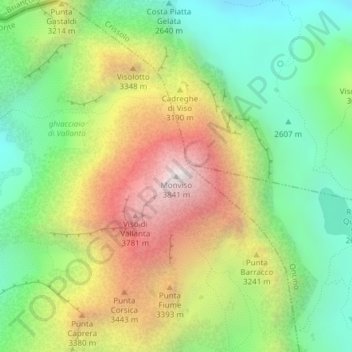
Nom : Carte topographique Monviso, altitude, relief.
Lieu : Monviso, Pontechianale, Cuneo, Piedmont, Italy (44.66739 7.08994 44.66749 7.09004)
Altitude moyenne : 2.985 m
Altitude minimum : 2.385 m
Altitude maximum : 3.831 m
Monte Viso is the location of a neolithic jadeite quarry, at an elevation of 2000 to 2400 metres. Its productivity peaked around 5000 BC. The jadeite was used to make cult axes, which are found all over western Europe. One such ceremonial axe head was found as far away as a small hill called Tristia in Western Ireland and is on display in the National Museum of Ireland – Archaeology, Dublin.
Autres cartes topographiques
Cliquez sur une carte pour visualiser sa topographie, son altitude et son relief.
Col Agnel / Colle dell'Agnello
Italy > Piedmont > Cuneo > Pontechianale
Col Agnel / Colle dell'Agnello, Pontechianale, Cuneo, Piedmont, Italy
Altitude moyenne : 2.700 m