
Carte topographique Braunwald
Carte interactive
Cliquez sur la carte pour afficher l’altitude.
À propos de cette carte
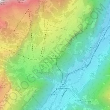
Nom : Carte topographique Braunwald, altitude, relief.
Lieu : Braunwald, Glarus Süd, Glarus, 8784, Switzerland (46.91926 8.97850 46.95926 9.01850)
Altitude moyenne : 1.215 m
Altitude minimum : 588 m
Altitude maximum : 2.399 m
Braunwald is situated in the Glarus Alps on a terrace above the Linth valley, at an elevation of 1,256 meters (4,121 ft). It overlooks the villages of Linthal and Rüti in the valley below. It is overlooked by the mountains of Ortstock (2,717 m or 8,914 ft), Höch Turm (2,666 m or 8,747 ft), Eggstock (2,455 m or 8,054 ft) and Bös Fulen (2,802 m or 9,193 ft).
Autres cartes topographiques
Cliquez sur une carte pour visualiser sa topographie, son altitude et son relief.
Schwanden
Switzerland > Glarus > Glarus Süd
Schwanden, Glarus Süd, Glarus, 8762, Switzerland
Altitude moyenne : 813 m
Schwander Grat
Switzerland > Glarus > Glarus Süd
Schwander Grat, Glarus Süd, Glarus, 8774, Switzerland
Altitude moyenne : 2.289 m
Tödi
Switzerland > Glarus > Glarus Süd
Tödi, Glarus Süd, Glarus, Switzerland
Altitude moyenne : 2.919 m
Mitlödi
Switzerland > Glarus > Glarus Süd > Mitlödi
Mitlödi, Glarus Süd, Glarus, 8756, Switzerland
Altitude moyenne : 800 m