
Carte topographique Schwanden
Carte interactive
Cliquez sur la carte pour afficher l’altitude.
Schwanden
Schwanden is situated at an elevation of 528 m (1,732 ft) at the point of confluence of the Linth and Sernf rivers. The village is located along the roads to Elm, Linthal and Schwändi, and includes the formerly independent (until 1876) hamlet of Thon. The villages of Nidfurn and Haslen lie to south in the valley of the Linth, whilst the village of Engi lies to the east in the valley of the Sernf. To the north, the village of Mitlödi lies in the valley of the Linth, whilst Schwandi and Sool are respectively on the west and east slopes of the valley.
À propos de cette carte
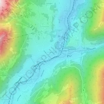
Nom : Carte topographique Schwanden, altitude, relief.
Lieu : Schwanden, Glarus Süd, Glarus, 8762, Switzerland (46.97556 9.05136 47.01556 9.09136)
Altitude moyenne : 813 m
Altitude minimum : 498 m
Altitude maximum : 1.744 m
Autres cartes topographiques
Cliquez sur une carte pour visualiser sa topographie, son altitude et son relief.