Géolocaliser

Carte topographique Towamba River

Cliquez sur la carte pour afficher l’altitude.

À propos de cette carte

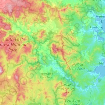
Nom : Carte topographique Towamba River, altitude, relief.

Lieu : Towamba River, New South Wales, Australia (-37.16474 149.42277 -36.88328 149.91379)

Altitude moyenne : 320 m

Altitude minimum : -6 m

Altitude maximum : 1.108 m

Autres cartes topographiques

Cliquez sur une carte pour visualiser sa topographie, son altitude et son relief.

Sydney

Australia > New South Wales

Sydney's topography is characterized by a diverse landscape that seamlessly blends coastal features with inland plateaus. The city is divided into two primary regions: the relatively flat Cumberland Plain to the south and west of Sydney Harbour, and the elevated Hornsby Plateau to the north. The Cumberland…

Altitude moyenne : 53 m

Hunter Valley

Australia > New South Wales > Cessnock

Altitude moyenne : 70 m

Newcastle

Australia > New South Wales

Altitude moyenne : 5 m

Central Coast Council

Australia > New South Wales

Altitude moyenne : 103 m

Ulladulla

Australia > New South Wales > Ulladulla

Altitude moyenne : 14 m

Mount Banks

Australia > New South Wales

Mount Banks, otherwise known as Mount King George, is a mountain within the Explorers Range of the Blue Mountains Range that is a spur off the Great Dividing Range, is located within the Blue Mountains National Park, approximately 100 kilometres (62 mi) west of Sydney in New South Wales, Australia. Mount Banks…

Altitude moyenne : 745 m

Grafton

Australia > New South Wales

Altitude moyenne : 36 m

Tweed Shire Council

Australia > New South Wales

Altitude moyenne : 212 m

Mount Kosciuszko

Australia > New South Wales

Mount Kosciuszko is the highest summit in mainland Australia. Until 1977 it was possible to drive from Charlotte Pass to within a few metres of the summit, but in 1977 the road was closed to public motor vehicle access due to environmental concerns. The road is open from Charlotte Pass for walkers and cyclists…

Altitude moyenne : 2.035 m

Grafton

Australia > New South Wales

Altitude moyenne : 5 m

Taree

Australia > New South Wales

Altitude moyenne : 17 m

Goulburn

Australia > New South Wales

Owing to its elevation, Goulburn has an oceanic climate (Cfb) with warm summers and cool winters; with a high diurnal range. Its climate is variable much of the year, though generally dry with maximum temperatures ranging from 11.8 °C (53.2 °F) in July to 28.3 °C (82.9 °F) in January. Rainfall is…

Altitude moyenne : 666 m

Govetts Leap

Australia > New South Wales

Altitude moyenne : 902 m

Blackheath

Australia > New South Wales

Blackheath (postcode: 2785) is an Australian town located near the highest point of the Blue Mountains, between Katoomba and Mount Victoria in New South Wales. The town's altitude is about 1,065 metres (3,494 ft) AHD  and it is located about 120 kilometres (75 mi) west north-west of Sydney, 11 kilometres…

Altitude moyenne : 893 m

Hornsby

Australia > New South Wales > Sydney

Altitude moyenne : 160 m

Eucumbene Cove

Australia > New South Wales

Altitude moyenne : 1.211 m

Katoomba Falls

Australia > New South Wales

Altitude moyenne : 837 m

Iluka

Australia > New South Wales

Altitude moyenne : 2 m

Armidale

Australia > New South Wales

Altitude moyenne : 1.036 m

Katoomba

Australia > New South Wales

Altitude moyenne : 904 m

Dorrigo

Australia > New South Wales > Dorrigo

Altitude moyenne : 721 m

Mudgee

Australia > New South Wales

Altitude moyenne : 535 m

Wollombi

Australia > New South Wales

Altitude moyenne : 200 m

Fairlight

Australia > New South Wales > Sydney

Altitude moyenne : 23 m

Bexhill

Australia > New South Wales

Altitude moyenne : 34 m

Mount Borah

Australia > New South Wales

Altitude moyenne : 657 m

Hampton

Australia > New South Wales

Altitude moyenne : 959 m

Pokolbin

Australia > New South Wales

Altitude moyenne : 135 m

Forster

Australia > New South Wales > Forster

Altitude moyenne : 4 m

Port Macquarie

Australia > New South Wales

Altitude moyenne : 5 m

Mullumbimby

Australia > New South Wales

Altitude moyenne : 29 m

Moree

Australia > New South Wales

Altitude moyenne : 216 m

Ocean Shores

Australia > New South Wales

Altitude moyenne : 12 m

Brunswick Heads

Australia > New South Wales

Altitude moyenne : 7 m

Wollemi National Park

Australia > New South Wales

Altitude moyenne : 521 m

Crescent Head

Australia > New South Wales

Altitude moyenne : 7 m

Gumma

Australia > New South Wales

Altitude moyenne : 9 m

Sydney

Australia > New South Wales

Phillip had been given no instructions for urban development, but in July 1788 submitted a plan for the new town at Sydney Cove. It included a wide central avenue, a permanent Government House, law courts, hospital and other public buildings, but no provision for warehouses, shops, or other commercial…

Altitude moyenne : 32 m

Merriwa

Australia > New South Wales

Altitude moyenne : 395 m

Waukivory

Australia > New South Wales

Altitude moyenne : 244 m

Fingal Head

Australia > New South Wales

Altitude moyenne : 4 m

Koreelah

Australia > New South Wales

Altitude moyenne : 608 m

Liston

Australia > New South Wales

Altitude moyenne : 855 m

Springdale

Australia > New South Wales

Altitude moyenne : 317 m

Ganbenang

Australia > New South Wales

Altitude moyenne : 811 m

Taylors Flat

Australia > New South Wales

Altitude moyenne : 555 m

Merriwa

Australia > New South Wales > Merriwa

Altitude moyenne : 314 m

Parramatta

Australia > New South Wales

Altitude moyenne : 22 m

Barrington Tops

Australia > New South Wales

Altitude moyenne : 1.107 m

Byron Bay

Australia > New South Wales

Byron Bay, located in northeastern New South Wales, Australia, is characterized by diverse topography shaped by its geological history. The town is part of the erosion caldera of the ancient Tweed Volcano, which erupted approximately 23 million years ago, resulting in the rich volcanic soils that define the…

Altitude moyenne : 7 m

Llandilo

Australia > New South Wales > Sydney

Altitude moyenne : 36 m

Marrickville

Australia > New South Wales > Sydney

Altitude moyenne : 17 m

Ryde

Australia > New South Wales > Sydney

Altitude moyenne : 52 m

Coraki

Australia > New South Wales

Altitude moyenne : 6 m

Carwoola

Australia > New South Wales

Altitude moyenne : 780 m

Glen Innes

Australia > New South Wales

Altitude moyenne : 1.083 m

Springwood

Australia > New South Wales > Sydney

Altitude moyenne : 335 m

Vincentia

Australia > New South Wales > Vincentia

Altitude moyenne : 15 m

Kellyville Ridge

Australia > New South Wales > Sydney

Altitude moyenne : 58 m

Nimbin

Australia > New South Wales

Altitude moyenne : 235 m

North Turramurra

Australia > New South Wales > Sydney

Altitude moyenne : 136 m

Sydney

Australia > New South Wales > Sydney

Altitude moyenne : 23 m

Thornleigh

Australia > New South Wales > Sydney

Thornleigh is bounded to the north by Waitara Creek and south by the Lane Cove National Park. Thornleigh borders the suburbs of Normanhurst, Hornsby, Wahroonga, Westleigh and Pennant Hills. Thornleigh offers great district views, and the topography varies greatly with many established areas built around…

Altitude moyenne : 159 m

Blackwattle Bay

Australia > New South Wales > Sydney

Altitude moyenne : 15 m

Gaanha-bula–Mount Canobolas

Australia > New South Wales

With an elevation of 1,390 metres (4,560 ft) above sea level, Mount Canobolas, an extinct volcano, is the highest mountain in the region. Situated 13 kilometres (8.1 mi) southwest of the city of Orange, it is about 250 kilometres (155 mi) west of Sydney.

Altitude moyenne : 1.186 m

Brown Mountain

Australia > New South Wales

Altitude moyenne : 1.160 m

Lilli Pilli

Australia > New South Wales > Sydney

Altitude moyenne : 21 m

Narrawallee

Australia > New South Wales

Altitude moyenne : 18 m

Comboyne

Australia > New South Wales

Altitude moyenne : 435 m

Kemps Creek

Australia > New South Wales > Sydney

Altitude moyenne : 63 m

Bar Mountain Lookout

Australia > New South Wales

Altitude moyenne : 703 m

Mullaway

Australia > New South Wales

Altitude moyenne : 10 m

Calderwood

Australia > New South Wales

Altitude moyenne : 100 m

Mooral Creek

Australia > New South Wales

Altitude moyenne : 247 m

Cootamundra

Australia > New South Wales

Altitude moyenne : 407 m

Yass

Australia > New South Wales

Yass is located 280 km south-west of Sydney, on the Hume Highway. The Yass River, which is a tributary of the Murrumbidgee River, flows through the town. Yass is 59 km from Canberra; lying at an elevation of 505 m AMSL.

Altitude moyenne : 533 m

Albury

Australia > New South Wales

Altitude moyenne : 246 m

Tahmoor

Australia > New South Wales

Altitude moyenne : 269 m

Captains Flat

Australia > New South Wales

Altitude moyenne : 957 m

Chatswood

Australia > New South Wales

Altitude moyenne : 81 m

Bungendore

Australia > New South Wales > Bungendore

Altitude moyenne : 727 m

Uki

Australia > New South Wales

Altitude moyenne : 84 m

Kyogle Council

Australia > New South Wales

Altitude moyenne : 315 m

Epping

Australia > New South Wales

Altitude moyenne : 96 m

Bredbo

Australia > New South Wales

Altitude moyenne : 929 m

Tocumwal

Australia > New South Wales

Altitude moyenne : 112 m

Quakers Hill

Australia > New South Wales

Altitude moyenne : 35 m

Terranora

Australia > New South Wales

Altitude moyenne : 34 m

Colebee

Australia > New South Wales

Altitude moyenne : 36 m

Équipez-vous pour votre prochaine aventure :

🧯Kits de survie - Équipement essentiel outdoor
🧢Bonnets de randonnée - Protection thermique légère
🪢Bâtons de trekking - Aide à la marche sur terrains accidentés
🔋Chargeurs de Piles - Pour alimenter GPS et lampes frontales
📟Altimètres Barométriques - Suivez votre dénivelé positif et les changements météo en temps réel

En tant que Partenaire Amazon, ce site perçoit une commission sur les achats éligibles sans surcoût pour vous.