Géolocaliser

Carte topographique Queanbeyan

Cliquez sur la carte pour afficher l’altitude.

À propos de cette carte

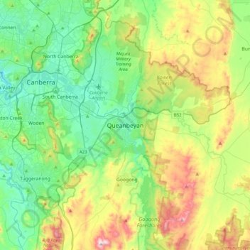
Nom : Carte topographique Queanbeyan, altitude, relief.

Lieu : Queanbeyan, Queanbeyan-Palerang Regional Council, New South Wales, 2619, Australia (-35.51245 149.07376 -35.19245 149.39376)

Altitude moyenne : 716 m

Altitude minimum : 514 m

Altitude maximum : 1.179 m

Autres cartes topographiques

Cliquez sur une carte pour visualiser sa topographie, son altitude et son relief.

Sydney

Australia > New South Wales

Sydney's topography is characterized by a diverse landscape that seamlessly blends coastal features with inland plateaus. The city is divided into two primary regions: the relatively flat Cumberland Plain to the south and west of Sydney Harbour, and the elevated Hornsby Plateau to the north. The Cumberland…

Altitude moyenne : 53 m

Newcastle

Australia > New South Wales

Altitude moyenne : 5 m

Cooranbong

Australia > New South Wales

Altitude moyenne : 72 m

Eden

Australia > New South Wales

Altitude moyenne : 55 m

Lismore

Australia > New South Wales

Altitude moyenne : 23 m

Bowral

Australia > New South Wales

Altitude moyenne : 690 m

Wingham

Australia > New South Wales

Altitude moyenne : 47 m

Byron Bay

Australia > New South Wales

Byron Bay, located in northeastern New South Wales, Australia, is characterized by diverse topography shaped by its geological history. The town is part of the erosion caldera of the ancient Tweed Volcano, which erupted approximately 23 million years ago, resulting in the rich volcanic soils that define the…

Altitude moyenne : 7 m

Goulburn

Australia > New South Wales

Owing to its elevation, Goulburn has an oceanic climate (Cfb) with warm summers and cool winters; with a high diurnal range. Its climate is variable much of the year, though generally dry with maximum temperatures ranging from 11.8 °C (53.2 °F) in July to 28.3 °C (82.9 °F) in January. Rainfall is…

Altitude moyenne : 666 m

North Parramatta

Australia > New South Wales > Sydney

Altitude moyenne : 42 m

Putney

Australia > New South Wales

Altitude moyenne : 18 m

Burringbar

Australia > New South Wales

Altitude moyenne : 81 m

Wagga Wagga

Australia > New South Wales

Altitude moyenne : 183 m

Penrith

Australia > New South Wales > Sydney > Penrith

Penrith is a city in New South Wales, Australia, located in Greater Western Sydney, 55 kilometres (31 mi) west of the Sydney central business district on the banks of the Nepean River, on the outskirts of the Cumberland Plain. Its elevation is 32 metres (105 ft).

Altitude moyenne : 34 m

Chatswood

Australia > New South Wales

Altitude moyenne : 81 m

Blackheath

Australia > New South Wales

Blackheath (postcode: 2785) is an Australian town located near the highest point of the Blue Mountains, between Katoomba and Mount Victoria in New South Wales. The town's altitude is about 1,065 metres (3,494 ft) AHD  and it is located about 120 kilometres (75 mi) west north-west of Sydney, 11 kilometres…

Altitude moyenne : 893 m

Umina Beach

Australia > New South Wales

Altitude moyenne : 38 m

Jindabyne

Australia > New South Wales

Altitude moyenne : 1.077 m

Tenterfield

Australia > New South Wales

Altitude moyenne : 891 m

Central Coast Council

Australia > New South Wales

Altitude moyenne : 103 m

Junee Shire Council

Australia > New South Wales

Altitude moyenne : 328 m

Camden Council

Australia > New South Wales

Altitude moyenne : 90 m

Perisher Valley

Australia > New South Wales

Altitude moyenne : 1.704 m

Balgowlah

Australia > New South Wales > Sydney

Altitude moyenne : 40 m

Bingara

Australia > New South Wales

Altitude moyenne : 394 m

Illawarra

Australia > New South Wales

Altitude moyenne : 234 m

Dirty Creek

Australia > New South Wales

Altitude moyenne : 77 m

Braidwood

Australia > New South Wales

Altitude moyenne : 674 m

Mebbin

Australia > New South Wales

Altitude moyenne : 400 m

Portland

Australia > New South Wales

At an altitude of 925 metres above sea level, Portland is the 21st highest town in Australia and classified as a temperate zone. Cool winters and warm summers ensure four distinct seasons and snowfalls each winter.

Altitude moyenne : 972 m

Nobbys Creek

Australia > New South Wales

Altitude moyenne : 66 m

Dalgety

Australia > New South Wales

Altitude moyenne : 866 m

Pimlico

Australia > New South Wales

Altitude moyenne : 34 m

Blueys Beach

Australia > New South Wales

Altitude moyenne : 33 m

Cowan

Australia > New South Wales

Altitude moyenne : 90 m

Barrington Tops

Australia > New South Wales

Altitude moyenne : 1.107 m

Port Macquarie

Australia > New South Wales

Altitude moyenne : 5 m

Wauchope

Australia > New South Wales

Altitude moyenne : 32 m

Crookwell

Australia > New South Wales

Crookwell is a small town located in the Southern Tablelands of New South Wales, Australia, in the Upper Lachlan Shire. At the 2016 census, Crookwell had a population of 2,641. The town is at a relatively high altitude of 887 metres and there are several snowfalls during the winter months. The nearest major…

Altitude moyenne : 904 m

Sydney

Australia > New South Wales > Sydney

Altitude moyenne : 23 m

Box Hill

Australia > New South Wales > Sydney

Altitude moyenne : 45 m

Blue Mountains

Australia > New South Wales

A sandstone plateau dominated by a landscape of endless eucalyptus forests, the Blue Mountains are located at the top of a 470-million-year-old quartzite. In the Permian period, a shallow sea covered the region, when rivers brought shales, siltstones and mudstones. Then during the Mesozoic period, rivers…

Altitude moyenne : 566 m

Mount Victoria

Australia > New South Wales

Mount Victoria (postcode: 2786) is a small township in the Blue Mountains of New South Wales, Australia. Mount Victoria is geographically the western most village and suburb of Greater Sydney on the great western highway in the City of Blue Mountains, located about 120 kilometres (75 mi) west-northwest by road…

Altitude moyenne : 901 m

Waverton

Australia > New South Wales > Sydney

Altitude moyenne : 33 m

St Leonards

Australia > New South Wales > Sydney

Altitude moyenne : 69 m

Snowball

Australia > New South Wales

Altitude moyenne : 1.001 m

Parramatta

Australia > New South Wales

Altitude moyenne : 22 m

Campbelltown

Australia > New South Wales

Altitude moyenne : 96 m

Singleton Council

Australia > New South Wales

Altitude moyenne : 238 m

Tahmoor

Australia > New South Wales

Altitude moyenne : 269 m

Greystanes

Australia > New South Wales > Sydney

Altitude moyenne : 53 m

Katoomba

Australia > New South Wales

Altitude moyenne : 904 m

Terrigal

Australia > New South Wales

Altitude moyenne : 13 m

Glen Innes

Australia > New South Wales

Altitude moyenne : 1.083 m

Manly Vale

Australia > New South Wales > Sydney

Altitude moyenne : 34 m

Kulnura

Australia > New South Wales

Altitude moyenne : 203 m

Dee Why

Australia > New South Wales > Sydney

Altitude moyenne : 31 m

Riverwood

Australia > New South Wales > Sydney

Altitude moyenne : 22 m

Toronto

Australia > New South Wales > Newcastle-Maitland

Altitude moyenne : 13 m

West Pennant Hills

Australia > New South Wales

Altitude moyenne : 130 m

Longneck Lagoon

Australia > New South Wales > Sydney

Altitude moyenne : 21 m

Molong

Australia > New South Wales

Altitude moyenne : 595 m

Glenhaven

Australia > New South Wales > Sydney

Altitude moyenne : 132 m

Gables

Australia > New South Wales > Sydney

Altitude moyenne : 47 m

Inner West

Australia > New South Wales > Sydney

Altitude moyenne : 19 m

Nerrigundah

Australia > New South Wales

Altitude moyenne : 189 m

South Maroota

Australia > New South Wales > Sydney

Altitude moyenne : 80 m

Norah Head

Australia > New South Wales

Altitude moyenne : 9 m

Mudgee

Australia > New South Wales

Altitude moyenne : 535 m

Leppington

Australia > New South Wales

Altitude moyenne : 89 m

Emmaville

Australia > New South Wales

Emmaville is at an elevation of 890 metres AHD. At the 2006 census, the Emmaville "urban centre/locality" had a population of 247 (in the 2001 census it was 303) and there were 535 persons usually resident in the Emmaville region.

Altitude moyenne : 859 m

Edmondson Park

Australia > New South Wales > Sydney

Altitude moyenne : 56 m

East Gosford

Australia > New South Wales

Altitude moyenne : 25 m

Glenwood

Australia > New South Wales

Altitude moyenne : 69 m

Hazelbrook

Australia > New South Wales

Hazelbrook is a town in New South Wales, Australia (Elevation: 675 metres) It is located 91 kilometres west of Sydney and 16 kilometres east of Katoomba in the Blue Mountains on the Great Western Highway.

Altitude moyenne : 610 m

Byron Shire Council

Australia > New South Wales

Altitude moyenne : 104 m

Crescent Head

Australia > New South Wales

Altitude moyenne : 7 m

Merci de soutenir ce site ❤️
Faire un don

Équipez-vous pour votre prochaine aventure :

En tant que Partenaire Amazon, ce site perçoit une commission sur les achats éligibles sans surcoût pour vous.

Bilgola Plateau

Australia > New South Wales

The suburb is mainly residential, with two small rows of shops, a small park and a primary school located on the top of the plateau. Bilgola Beach on the eastern side features a surf club and kiosk. Rising to an elevation of 150m above sea level, the suburb has views of the beach and the ocean on the eastern…

Altitude moyenne : 37 m

Kingscliff

Australia > New South Wales

Altitude moyenne : 5 m

Nepean River

Australia > New South Wales

Altitude moyenne : 601 m

Orange

Australia > New South Wales

Orange is a city in the Central Tablelands region of New South Wales, Australia. It is 254 km (158 mi) west of the state capital, Sydney [206 km (128 mi) on a great circle], at an altitude of 862 metres (2,828 ft). Orange had an estimated urban population of 40,493 as of June 2018 making the city a significant…

Altitude moyenne : 852 m

Cromer

Australia > New South Wales

Altitude moyenne : 46 m

East Lismore

Australia > New South Wales

Altitude moyenne : 41 m

Nymboida

Australia > New South Wales

Altitude moyenne : 280 m

Équipez-vous pour votre prochaine aventure :

🧼Entretien Chaussures - Prolongez la vie de vos bottes de randonnée
🛰️GPS Garmin randonnée - GPS Garmin reconnus pour la randonnée et le trekking
🦟Répulsifs Insectes - Protection contre les tiques et moustiques en forêt
🥢Bâtons de Marche - Améliorez votre stabilité sur les terrains accidentés
🧥Vestes coupe-vent - Protection contre le vent

En tant que Partenaire Amazon, ce site perçoit une commission sur les achats éligibles sans surcoût pour vous.