
Faire un don
Équipez-vous pour votre prochaine aventure :
En tant que Partenaire Amazon, ce site perçoit une commission sur les achats éligibles sans surcoût pour vous.
Carte topographique Vulkaneifel
Cliquez sur la carte pour afficher l’altitude.
Faire un don
Équipez-vous pour votre prochaine aventure :
En tant que Partenaire Amazon, ce site perçoit une commission sur les achats éligibles sans surcoût pour vous.
À propos de cette carte
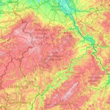
Nom : Carte topographique Vulkaneifel, altitude, relief.
Lieu : Vulkaneifel, Rhineland-Palatinate, 54550, Germany (49.51276 6.12790 50.91276 7.52790)
Altitude moyenne : 339 m
Altitude minimum : 41 m
Altitude maximum : 809 m
Faire un don
Équipez-vous pour votre prochaine aventure :
En tant que Partenaire Amazon, ce site perçoit une commission sur les achats éligibles sans surcoût pour vous.
Autres cartes topographiques
Cliquez sur une carte pour visualiser sa topographie, son altitude et son relief.
Nürburg
Germany > Rhineland-Palatinate > Landkreis Ahrweiler
Nürburg has a semi-continental climate with both oceanic and continental tendencies. It does however land in the former category (Köppen Cfb). With regards to the racetrack, due to the Nordschleife's varied terrain and elevation, weather may be completely different on either end of the track. The elevation…
Altitude moyenne : 560 m
Mainz
Germany > Rhineland-Palatinate
Nevertheless, the post-war reconstruction took place very slowly. While cities such as Frankfurt had been rebuilt fast by a central authority, only individual efforts were initially successful in rebuilding Mainz. The reason for this was that the French wanted Mainz to expand and become a model city. Mainz lay…
Altitude moyenne : 132 m
Faire un don
Équipez-vous pour votre prochaine aventure :
En tant que Partenaire Amazon, ce site perçoit une commission sur les achats éligibles sans surcoût pour vous.
Ramstein-Miesenbach
Germany > Rhineland-Palatinate > Landkreis Kaiserslautern
Altitude moyenne : 266 m
Eltz Castle
Germany > Rhineland-Palatinate > Landkreis Mayen-Koblenz > Wierschem
Altitude moyenne : 219 m
Faire un don
Équipez-vous pour votre prochaine aventure :
En tant que Partenaire Amazon, ce site perçoit une commission sur les achats éligibles sans surcoût pour vous.
Faire un don
Équipez-vous pour votre prochaine aventure :
En tant que Partenaire Amazon, ce site perçoit une commission sur les achats éligibles sans surcoût pour vous.
Faire un don
Équipez-vous pour votre prochaine aventure :
En tant que Partenaire Amazon, ce site perçoit une commission sur les achats éligibles sans surcoût pour vous.
Faire un don
Équipez-vous pour votre prochaine aventure :
En tant que Partenaire Amazon, ce site perçoit une commission sur les achats éligibles sans surcoût pour vous.
Friedewald
Germany > Rhineland-Palatinate > Landkreis Altenkirchen (Westerwald)
Altitude moyenne : 484 m
Monbijou
Germany > Rhineland-Palatinate > Südwestpfalz > Dietrichingen > Monbijou
Altitude moyenne : 302 m
Faire un don
Équipez-vous pour votre prochaine aventure :
En tant que Partenaire Amazon, ce site perçoit une commission sur les achats éligibles sans surcoût pour vous.
Ramstein-Miesenbach
Germany > Rhineland-Palatinate > Landkreis Kaiserslautern
Altitude moyenne : 266 m
Faire un don
Équipez-vous pour votre prochaine aventure :
En tant que Partenaire Amazon, ce site perçoit une commission sur les achats éligibles sans surcoût pour vous.
Mainz
Germany > Rhineland-Palatinate
The destruction caused by the Bombing of Mainz in World War II led to the most intense phase of building in the history of the town. During the last war in Germany, more than 30 air raids destroyed about 80 per cent of the city's centre, including most of the historic buildings. The attack on the afternoon of…
Altitude moyenne : 132 m
Faire un don
Équipez-vous pour votre prochaine aventure :
En tant que Partenaire Amazon, ce site perçoit une commission sur les achats éligibles sans surcoût pour vous.
Ahr
Germany > Rhineland-Palatinate
Ahr (German pronunciation: [ˈaːɐ̯]) is a river in Germany, a left tributary of the Rhine. Its source is at an elevation of approximately 470 metres (1,540 ft) above sea level in Blankenheim in the Eifel, in the cellar of a timber-frame house near the castle of Blankenheim. After 18 kilometres (11 mi) it…
Altitude moyenne : 367 m
Faire un don
Équipez-vous pour votre prochaine aventure :
En tant que Partenaire Amazon, ce site perçoit une commission sur les achats éligibles sans surcoût pour vous.
Carlsberg
Germany > Rhineland-Palatinate > Landkreis Bad Dürkheim
The municipality lies at the north edge of the Palatinate Forest between the Haardt range in the south and the Autobahn A 6 in the north in the Leiningerland at an elevation of 285 m above sea level. Carlsberg belongs to the Verbandsgemeinde of Leiningerland, whose seat is in Grünstadt.
Altitude moyenne : 327 m
Faire un don
Équipez-vous pour votre prochaine aventure :
En tant que Partenaire Amazon, ce site perçoit une commission sur les achats éligibles sans surcoût pour vous.
Mainz
Germany > Rhineland-Palatinate
The destruction caused by the Bombing of Mainz in World War II led to the most intense phase of building in the history of the town. During the last war in Germany, more than 30 air raids destroyed about 80 per cent of the city's centre, including most of the historic buildings. The attack on the afternoon of…
Altitude moyenne : 132 m
Faire un don
Équipez-vous pour votre prochaine aventure :
En tant que Partenaire Amazon, ce site perçoit une commission sur les achats éligibles sans surcoût pour vous.
Wackernheim
Germany > Rhineland-Palatinate > Landkreis Mainz-Bingen > Ingelheim am Rhein
Altitude moyenne : 220 m
Birgel
Germany > Rhineland-Palatinate > Landkreis Vulkaneifel
The municipality belongs to the Kalkeifel (“Limestone Eifel”) and lies on the southern edge of the Dollendorf Limestone Basin (Dollendorfer Kalkmulde). The elevation ranges from about 400 m above sea level on the Kyll at Crumpsmühle to about 526 m above sea level at the Hirzberg (mountain).
Altitude moyenne : 450 m
Faire un don
Équipez-vous pour votre prochaine aventure :
En tant que Partenaire Amazon, ce site perçoit une commission sur les achats éligibles sans surcoût pour vous.
Falkenstein
Germany > Rhineland-Palatinate > Donnersbergkreis
The linear settlement is located along an old pass road that reaches its highest elevation at 464 m (1522 ft). The village's main street is one of the steepest public roads in Germany with a 25% gradient. Along the road to Winnweiler the Falkensteiner Tal (Falkenstein Valley), known for its rock formations is…
Altitude moyenne : 412 m
Laudert
Germany > Rhineland-Palatinate > Rhein-Hunsrück-Kreis
North of Laudert, cleft here and there by the Autobahn or high-voltage transmission lines, is an otherwise continuous expanse of higher-elevation forest growing above mainly greywacke bedrock. In these woods, roughly a kilometre away from the village, in a swampy area that once afforded protection against…
Altitude moyenne : 490 m
Faire un don
Équipez-vous pour votre prochaine aventure :
En tant que Partenaire Amazon, ce site perçoit une commission sur les achats éligibles sans surcoût pour vous.
Schönenberg-Kübelberg
Germany > Rhineland-Palatinate > Landkreis Kusel
The municipality of Schönenberg-Kübelberg lies in the Western Palatinate near the boundary with the Saarland some 15 km south of Kusel, and 10 km northeast of Homburg. The two Ortsteile lie at the edge of the Landstuhler Bruch (a hollow). Kübelberg on the long mountain ridge south of the Klingbach runs…
Altitude moyenne : 268 m
Betzdorf
Germany > Rhineland-Palatinate > Landkreis Altenkirchen (Westerwald)
Altitude moyenne : 277 m
Faire un don
Équipez-vous pour votre prochaine aventure :
En tant que Partenaire Amazon, ce site perçoit une commission sur les achats éligibles sans surcoût pour vous.
Faire un don
Équipez-vous pour votre prochaine aventure :
En tant que Partenaire Amazon, ce site perçoit une commission sur les achats éligibles sans surcoût pour vous.
Faire un don
Équipez-vous pour votre prochaine aventure :
En tant que Partenaire Amazon, ce site perçoit une commission sur les achats éligibles sans surcoût pour vous.
Faire un don
Équipez-vous pour votre prochaine aventure :
En tant que Partenaire Amazon, ce site perçoit une commission sur les achats éligibles sans surcoût pour vous.
Altenglan
Germany > Rhineland-Palatinate > Landkreis Kusel
The municipality lies in the uplands in the Western Palatinate on the river Glan, which is the village's namesake, at an elevation in the valley of some 200 m above sea level, although the elevations within municipal limits reach almost 400 m (Bistersberg 387 m on the Glan's left bank; Kalmet 390 m on the…
Altitude moyenne : 305 m
Faire un don
Équipez-vous pour votre prochaine aventure :
En tant que Partenaire Amazon, ce site perçoit une commission sur les achats éligibles sans surcoût pour vous.
Faire un don
Équipez-vous pour votre prochaine aventure :
En tant que Partenaire Amazon, ce site perçoit une commission sur les achats éligibles sans surcoût pour vous.
Faire un don
Équipez-vous pour votre prochaine aventure :
En tant que Partenaire Amazon, ce site perçoit une commission sur les achats éligibles sans surcoût pour vous.
Horhausen (Westerwald)
Germany > Rhineland-Palatinate > Landkreis Altenkirchen (Westerwald)
Altitude moyenne : 310 m
Faire un don
Équipez-vous pour votre prochaine aventure :
En tant que Partenaire Amazon, ce site perçoit une commission sur les achats éligibles sans surcoût pour vous.
Karbach
Germany > Rhineland-Palatinate > Rhein-Hunsrück-Kreis
The municipality lies in the Hunsrück some 4 km east of Emmelshausen and 7 km west of Sankt Goar, the town on the Rhine. It is linked to the national road network by the Autobahn A 61 (Emmelshausen interchange) and Bundesstraße 327, also called the Hunsrückhöhenstraße (“Hunsrück Heights Road”, a…
Altitude moyenne : 416 m
Hahn Airport
Germany > Rhineland-Palatinate > Rhein-Hunsrück-Kreis > Lautzenhausen
Altitude moyenne : 472 m
Faire un don
Équipez-vous pour votre prochaine aventure :
En tant que Partenaire Amazon, ce site perçoit une commission sur les achats éligibles sans surcoût pour vous.
Nürburg
Germany > Rhineland-Palatinate > Landkreis Ahrweiler
Nürburg has a semi-continental climate with both oceanic and continental tendencies. It does however land in the former category (Köppen Cfb). With regards to the racetrack, due to the Nordschleife's varied terrain and elevation, weather may be completely different on either end of the track. The elevation…
Altitude moyenne : 560 m
Niederbettingen
Germany > Rhineland-Palatinate > Landkreis Vulkaneifel > Hillesheim
Altitude moyenne : 437 m
Faire un don
Équipez-vous pour votre prochaine aventure :
En tant que Partenaire Amazon, ce site perçoit une commission sur les achats éligibles sans surcoût pour vous.
Faire un don
Équipez-vous pour votre prochaine aventure :
En tant que Partenaire Amazon, ce site perçoit une commission sur les achats éligibles sans surcoût pour vous.
53578
Germany > Rhineland-Palatinate > Landkreis Neuwied > Windhagen > Johannisberg
Altitude moyenne : 261 m
Faire un don
Équipez-vous pour votre prochaine aventure :
En tant que Partenaire Amazon, ce site perçoit une commission sur les achats éligibles sans surcoût pour vous.