
Faire un don
Équipez-vous pour votre prochaine aventure :
En tant que Partenaire Amazon, ce site perçoit une commission sur les achats éligibles sans surcoût pour vous.
Carte topographique Schönenberg-Kübelberg
Cliquez sur la carte pour afficher l’altitude.
Faire un don
Équipez-vous pour votre prochaine aventure :
En tant que Partenaire Amazon, ce site perçoit une commission sur les achats éligibles sans surcoût pour vous.
Schönenberg-Kübelberg
The municipality of Schönenberg-Kübelberg lies in the Western Palatinate near the boundary with the Saarland some 15 km south of Kusel, and 10 km northeast of Homburg. The two Ortsteile lie at the edge of the Landstuhler Bruch (a hollow). Kübelberg on the long mountain ridge south of the Klingbach runs seamlessly into Schönenberg to the east, while Schönenberg also melds without a break with the outlying centre of Sand. Within the municipality, the land rises from 241 m above sea level at the edge of the brook up to 264 m near the church in Kübelberg. Outside the built-up area, the highest elevations in the municipal area reach some 300 m above sea level in the Steinwald and Peterswald (forests).
Faire un don
Équipez-vous pour votre prochaine aventure :
En tant que Partenaire Amazon, ce site perçoit une commission sur les achats éligibles sans surcoût pour vous.
À propos de cette carte
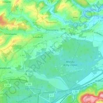
Nom : Carte topographique Schönenberg-Kübelberg, altitude, relief.
Altitude moyenne : 268 m
Altitude minimum : 221 m
Altitude maximum : 396 m
Faire un don
Équipez-vous pour votre prochaine aventure :
En tant que Partenaire Amazon, ce site perçoit une commission sur les achats éligibles sans surcoût pour vous.
Autres cartes topographiques
Cliquez sur une carte pour visualiser sa topographie, son altitude et son relief.
Schönenberg
Germany > Rhineland-Palatinate > Landkreis Kusel > Schönenberg-Kübelberg
Altitude moyenne : 266 m