Carte topographique Haslet
Carte interactive
Cliquez sur la carte pour afficher l’altitude.
À propos de cette carte
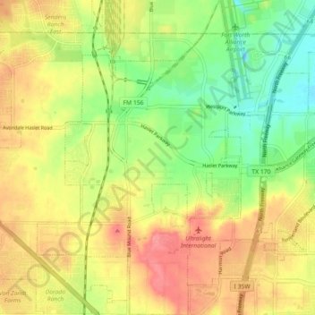
Nom : Carte topographique Haslet, altitude, relief.
Lieu : Haslet, Tarrant County, Texas, United States (32.92417 -97.36684 32.99920 -97.30980)
Altitude moyenne : 227 m
Altitude minimum : 192 m
Altitude maximum : 260 m
Autres cartes topographiques
Cliquez sur une carte pour visualiser sa topographie, son altitude et son relief.
Fort Worth
United States > Texas > Tarrant County
Fort Worth, Tarrant County, Texas, United States
Altitude moyenne : 212 m
Moselle
United States > Texas > Tarrant County > Fort Worth
Moselle, Fort Worth, Tarrant County, Texas, 76134, United States
Altitude moyenne : 233 m
Saginaw
United States > Texas > Tarrant County
Saginaw, Tarrant County, Texas, United States
Altitude moyenne : 216 m
Eagle Mountain Lake
United States > Texas > Tarrant County > Pelican Bay
Eagle Mountain Lake, Pelican Bay, Tarrant County, Texas, United States
Altitude moyenne : 228 m
Southlake
United States > Texas > Tarrant County
Southlake, Tarrant County, Texas, 76092, United States
Altitude moyenne : 186 m
Mansfield
United States > Texas > Tarrant County
Mansfield, Tarrant County, Texas, 76063, United States
Altitude moyenne : 195 m
Colleyville
United States > Texas > Tarrant County
Colleyville, Tarrant County, Texas, 76034, United States
Altitude moyenne : 191 m
Peden
United States > Texas > Tarrant County
Peden, Tarrant County, Texas, 76020, United States
Altitude moyenne : 221 m
North Richland Hills
United States > Texas > Tarrant County
North Richland Hills, Tarrant County, Texas, United States
Altitude moyenne : 191 m
Rendon
United States > Texas > Tarrant County > Fort Worth
Rendon, Fort Worth, Tarrant County, Texas, United States
Altitude moyenne : 221 m
Azle
United States > Texas > Tarrant County > Azle
Azle, Tarrant County, Texas, 76020, United States
Altitude moyenne : 224 m
Crowley
United States > Texas > Tarrant County
Crowley, Tarrant County, Texas, United States
Altitude moyenne : 236 m
Boomtown
United States > Texas > Tarrant County > Arlington
Boomtown, Arlington, Tarrant County, Texas, 76011, United States
Altitude moyenne : 170 m
Watauga
United States > Texas > Tarrant County
Watauga, Tarrant County, Texas, 76148, United States
Altitude moyenne : 198 m
Fort Worth
United States > Texas > Tarrant County > Fort Worth
Fort Worth, Tarrant County, Texas, 76102, United States
Altitude moyenne : 202 m
White Settlement
United States > Texas > Tarrant County
White Settlement, Tarrant County, Texas, United States
Altitude moyenne : 211 m
Bedford
United States > Texas > Tarrant County > Bedford
Bedford, Tarrant County, Texas, United States
Altitude moyenne : 180 m
Glenwood Park
United States > Texas > Tarrant County > Fort Worth
Glenwood Park, Fort Worth, Tarrant County, Texas, 76104, United States
Altitude moyenne : 179 m
Southlake
United States > Texas > Tarrant County > Southlake > Southlake
Southlake, Tarrant County, Texas, 76092, United States
Altitude moyenne : 190 m
Arlington
United States > Texas > Tarrant County
Arlington, Tarrant County, Texas, United States
Altitude moyenne : 174 m
Mansfield
United States > Texas > Tarrant County > Mansfield
Mansfield, Tarrant County, Texas, 76063, United States
Altitude moyenne : 195 m
Ederville
United States > Texas > Tarrant County > Fort Worth > Ederville
Ederville, Fort Worth, Tarrant County, Texas, 76112, United States
Altitude moyenne : 187 m
Grapevine
United States > Texas > Tarrant County
Grapevine, Tarrant County, Texas, United States
Altitude moyenne : 176 m
Forest Hill
United States > Texas > Tarrant County
Forest Hill, Tarrant County, Texas, United States
Altitude moyenne : 198 m
Keller
United States > Texas > Tarrant County
Keller, Tarrant County, Texas, 76248, United States
Altitude moyenne : 213 m
Hurst
United States > Texas > Tarrant County
Hurst, Tarrant County, Texas, United States
Altitude moyenne : 182 m