
Carte topographique Utah County
Carte interactive
Cliquez sur la carte pour afficher l’altitude.
À propos de cette carte
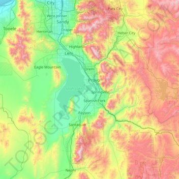
Nom : Carte topographique Utah County, altitude, relief.
Lieu : Utah County, Utah, United States (39.77625 -112.21419 40.57791 -110.85765)
Altitude moyenne : 2.016 m
Altitude minimum : 1.280 m
Altitude maximum : 3.582 m
Utah Valley lies at the center of the county, lined by the mountains of the Wasatch Range on the east. Utah Lake occupies a large part of the valley. The elevation ranges from 4,487 feet (1,368 m) above sea level at the lake to 11,928 feet (3,636 m) at the peak of Mount Nebo.
Autres cartes topographiques
Cliquez sur une carte pour visualiser sa topographie, son altitude et son relief.
Saint George
United States > Utah > Washington County
Saint George, Washington County, Utah, United States
Altitude moyenne : 929 m
Taylorsville
United States > Utah > Salt Lake County
Taylorsville, Salt Lake County, Utah, United States
Altitude moyenne : 1.325 m
Zion National Park
United States > Utah > Washington County
Zion National Park, Washington County, Utah, United States
Altitude moyenne : 1.877 m
Hatch
United States > Utah > Garfield County
Hatch, Garfield County, Utah, 84735, United States
Altitude moyenne : 2.135 m
Draper Commercial Parkway
United States > Utah > Salt Lake County > Draper
Draper Commercial Parkway, Draper, Salt Lake County, Utah, 84020, United States
Altitude moyenne : 1.355 m
Midlake
United States > Utah > Box Elder County
Midlake, Box Elder County, Utah, United States
Altitude moyenne : 1.282 m
Pinto Lake
United States > Utah > Duchesne County
Pinto Lake, Duchesne County, Utah, United States
Altitude moyenne : 3.106 m
Gates Lake
United States > Utah > Duchesne County
Gates Lake, Duchesne County, Utah, United States
Altitude moyenne : 3.121 m
Park City
United States > Utah > Summit County
Park City, Summit County, Utah, United States
Altitude moyenne : 2.290 m
Stettler
United States > Utah > Weber County > Ogden
Stettler, Ogden, Weber County, Utah, 84404, United States
Altitude moyenne : 1.474 m
Jeremy Ranch
United States > Utah > Summit County
Jeremy Ranch, Summit County, Utah, 84098, United States
Altitude moyenne : 2.048 m
Magna
United States > Utah > Salt Lake County
Magna, Salt Lake County, Utah, United States
Altitude moyenne : 1.341 m
Coal Creek
United States > Utah > Iron County > Cedar City
Coal Creek, Cedar City, Iron County, Utah, United States
Altitude moyenne : 1.922 m
Bellwood Acres
United States > Utah > Salt Lake County > Cottonwood Heights
Bellwood Acres, Cottonwood Heights, Salt Lake County, Utah, 84121, United States
Altitude moyenne : 1.398 m
Fish Lake
United States > Utah > Sevier County
Fish Lake, Sevier County, Utah, United States
Altitude moyenne : 2.886 m
American Fork
United States > Utah > Utah County
American Fork, Utah County, Utah, 84003, United States
Altitude moyenne : 1.405 m
Sprucewood
United States > Utah > Salt Lake County > Sandy
Sprucewood, Sandy, Salt Lake County, Utah, 84094, United States
Altitude moyenne : 1.418 m
Salt Lake City
United States > Utah > Salt Lake County > Salt Lake City
Salt Lake City, Salt Lake County, Utah, 84139, United States
Altitude moyenne : 1.625 m
New Harmony
United States > Utah > Washington County
New Harmony, Washington County, Utah, United States
Altitude moyenne : 1.636 m
West Valley City
United States > Utah > Salt Lake County
West Valley City, Salt Lake County, Utah, United States
Altitude moyenne : 1.351 m
Wildwood
United States > Utah > Utah County
Wildwood, Utah County, Utah, United States
Altitude moyenne : 1.879 m
Alta
United States > Utah > Salt Lake County
Alta, Salt Lake County, Utah, United States
Altitude moyenne : 2.912 m
Brighton
United States > Utah > Salt Lake County
Brighton, Salt Lake County, Utah, United States
Altitude moyenne : 2.852 m
West Jordan
United States > Utah > Salt Lake County
West Jordan, Salt Lake County, Utah, United States
Altitude moyenne : 1.372 m
Alta Vista
United States > Utah > Weber County > Ogden
Alta Vista, Ogden, Weber County, Utah, United States
Altitude moyenne : 1.505 m
Midvale
United States > Utah > Salt Lake County
Midvale, Salt Lake County, Utah, 84047, United States
Altitude moyenne : 1.331 m
Woods Cross
United States > Utah > Davis County
Woods Cross, Davis County, Utah, 84087, United States
Altitude moyenne : 1.352 m
Salt Lake City
United States > Utah > Salt Lake County
Salt Lake City, Salt Lake County, Utah, United States
Altitude moyenne : 1.592 m
Midway
United States > Utah > Wasatch County
Midway, Wasatch County, Utah, 84049, United States
Altitude moyenne : 1.751 m
Three Canyon Rapids
United States > Utah > Carbon County
Three Canyon Rapids, Carbon County, Utah, United States
Altitude moyenne : 1.511 m
Sandy
United States > Utah > Salt Lake County
Sandy, Salt Lake County, Utah, United States
Altitude moyenne : 1.376 m
Moab
United States > Utah > Grand County
Moab, Grand County, Utah, 84532, United States
Altitude moyenne : 1.357 m
Hillborough Heights
United States > Utah > Salt Lake County > Sandy > Hillborough Heights
Hillborough Heights, Sandy, Salt Lake County, Utah, 84093, United States
Altitude moyenne : 1.501 m
South Valence Drainage
United States > Utah > Salt Lake County > West Jordan
South Valence Drainage, West Jordan, Salt Lake County, Utah, United States
Altitude moyenne : 1.388 m
Lake Powell
United States > Utah > Kane County
Lake Powell, Kane County, Utah, United States
Altitude moyenne : 1.555 m
Millcreek
United States > Utah > Salt Lake County > Millcreek
Millcreek, Salt Lake County, Utah, 84106, United States
Altitude moyenne : 1.715 m
Cannonville
United States > Utah > Garfield County > Cannonville
Cannonville, Garfield County, Utah, 84718, United States
Altitude moyenne : 1.894 m
South Jordan
United States > Utah > Salt Lake County > South Jordan
South Jordan, Salt Lake County, Utah, United States
Altitude moyenne : 1.384 m
Riverton
United States > Utah > Riverton > Riverton
Riverton, Salt Lake County, Utah, 84065, United States
Altitude moyenne : 1.376 m
Wildcat Hills
United States > Utah > Box Elder County
Wildcat Hills, Box Elder County, Utah, United States
Altitude moyenne : 1.464 m
Park City
United States > Utah > Summit County > Park City
Park City, Summit County, Utah, 84060, United States
Altitude moyenne : 2.315 m
Peter Sinks
Peter Sinks, Cache County, Utah, United States
Altitude moyenne : 2.555 m
Cedar City
United States > Utah > Iron County
Cedar City, Iron County, Utah, United States
Altitude moyenne : 1.975 m
Provo
United States > Utah > Utah County > Provo
Provo, Utah County, Utah, 84606, United States
Altitude moyenne : 1.733 m
Huntsville
United States > Utah > Huntsville
Huntsville, Weber County, Utah, United States
Altitude moyenne : 1.502 m