
Carte topographique Alta
Carte interactive
Cliquez sur la carte pour afficher l’altitude.
À propos de cette carte
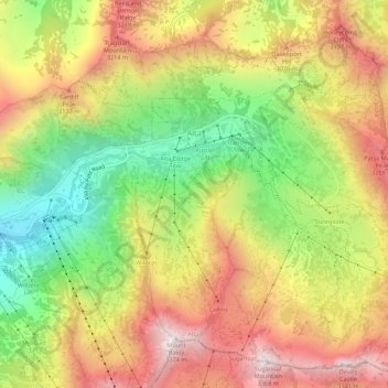
Nom : Carte topographique Alta, altitude, relief.
Lieu : Alta, Salt Lake County, Utah, United States (40.56441 -111.65273 40.60326 -111.59808)
Altitude moyenne : 2.912 m
Altitude minimum : 2.437 m
Altitude maximum : 3.369 m
Alta experiences a high altitude humid continental climate (Köppen Dfb), which borders on a subalpine climate (Dfc), due to its high elevation. Due to its proximity to the Great Salt Lake, the town receives very heavy snows, averaging over 507 inches (12.9 m) per year. During the very wet season of 1982/1983, Alta received as much as 900 inches (23 m) of snow, leading to record flooding of Wasatch streams as the snow melted during May and June that year. Alta's total precipitation of 108.54 inches (2,756.9 mm) during 1983 is a record for a calendar year in any state of the Mountain West;.
Autres cartes topographiques
Cliquez sur une carte pour visualiser sa topographie, son altitude et son relief.
Taylorsville
United States > Utah > Salt Lake County
Taylorsville, Salt Lake County, Utah, United States
Altitude moyenne : 1.325 m
Draper Commercial Parkway
United States > Utah > Salt Lake County > Draper
Draper Commercial Parkway, Draper, Salt Lake County, Utah, 84020, United States
Altitude moyenne : 1.355 m
Magna
United States > Utah > Salt Lake County
Magna, Salt Lake County, Utah, United States
Altitude moyenne : 1.341 m
Bellwood Acres
United States > Utah > Salt Lake County > Cottonwood Heights
Bellwood Acres, Cottonwood Heights, Salt Lake County, Utah, 84121, United States
Altitude moyenne : 1.398 m
Sprucewood
United States > Utah > Salt Lake County > Sandy
Sprucewood, Sandy, Salt Lake County, Utah, 84094, United States
Altitude moyenne : 1.418 m
Salt Lake City
United States > Utah > Salt Lake County > Salt Lake City
Salt Lake City, Salt Lake County, Utah, 84139, United States
Altitude moyenne : 1.625 m
West Valley City
United States > Utah > Salt Lake County
West Valley City, Salt Lake County, Utah, United States
Altitude moyenne : 1.351 m
Brighton
United States > Utah > Salt Lake County
Brighton, Salt Lake County, Utah, United States
Altitude moyenne : 2.852 m
West Jordan
United States > Utah > Salt Lake County
West Jordan, Salt Lake County, Utah, United States
Altitude moyenne : 1.372 m
Midvale
United States > Utah > Salt Lake County
Midvale, Salt Lake County, Utah, 84047, United States
Altitude moyenne : 1.331 m
Salt Lake City
United States > Utah > Salt Lake County
Salt Lake City, Salt Lake County, Utah, United States
Altitude moyenne : 1.592 m
Sandy
United States > Utah > Salt Lake County
Sandy, Salt Lake County, Utah, United States
Altitude moyenne : 1.376 m
Hillborough Heights
United States > Utah > Salt Lake County > Sandy > Hillborough Heights
Hillborough Heights, Sandy, Salt Lake County, Utah, 84093, United States
Altitude moyenne : 1.501 m
South Valence Drainage
United States > Utah > Salt Lake County > West Jordan
South Valence Drainage, West Jordan, Salt Lake County, Utah, United States
Altitude moyenne : 1.388 m
Millcreek
United States > Utah > Salt Lake County > Millcreek
Millcreek, Salt Lake County, Utah, 84106, United States
Altitude moyenne : 1.715 m
South Jordan
United States > Utah > Salt Lake County > South Jordan
South Jordan, Salt Lake County, Utah, United States
Altitude moyenne : 1.384 m
Snowbird
United States > Utah > Salt Lake County
Snowbird, Salt Lake County, Utah, 85092, United States
Altitude moyenne : 2.760 m