
Faire un don
Équipez-vous pour votre prochaine aventure :
En tant que Partenaire Amazon, ce site perçoit une commission sur les achats éligibles sans surcoût pour vous.
Carte topographique Area H (Cultus Lake/Columbia Valley)
Cliquez sur la carte pour afficher l’altitude.
Faire un don
Équipez-vous pour votre prochaine aventure :
En tant que Partenaire Amazon, ce site perçoit une commission sur les achats éligibles sans surcoût pour vous.
À propos de cette carte
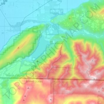
Nom : Carte topographique Area H (Cultus Lake/Columbia Valley), altitude, relief.
Altitude moyenne : 566 m
Altitude minimum : 0 m
Altitude maximum : 1.786 m
Faire un don
Équipez-vous pour votre prochaine aventure :
En tant que Partenaire Amazon, ce site perçoit une commission sur les achats éligibles sans surcoût pour vous.
Autres cartes topographiques
Cliquez sur une carte pour visualiser sa topographie, son altitude et son relief.
Durieu
Canada > British Columbia > Fraser Valley Regional District > Area F (McConnell Creek/Hatzic Prairie)
Altitude moyenne : 142 m
Hope Slide
Canada > British Columbia > Fraser Valley Regional District > Area B (South Fraser Canyon/Sunshine Valley)
Altitude moyenne : 1.160 m
Cheam Peak
Canada > British Columbia > Fraser Valley Regional District > Area E (Chilliwack River Valley)
Altitude moyenne : 1.471 m
Hope
Canada > British Columbia > Fraser Valley Regional District > Hope > Hope
Altitude moyenne : 435 m
Faire un don
Équipez-vous pour votre prochaine aventure :
En tant que Partenaire Amazon, ce site perçoit une commission sur les achats éligibles sans surcoût pour vous.
Silver Peak
Canada > British Columbia > Fraser Valley Regional District > Area B (South Fraser Canyon/Sunshine Valley)
Altitude moyenne : 1.354 m
Harrison River
Canada > British Columbia > Fraser Valley Regional District > Kent > Harrison Mills
Altitude moyenne : 45 m
Sumas River
Canada > British Columbia > Fraser Valley Regional District > Abbotsford
Altitude moyenne : 167 m
Faire un don
Équipez-vous pour votre prochaine aventure :
En tant que Partenaire Amazon, ce site perçoit une commission sur les achats éligibles sans surcoût pour vous.
Pattinson Peak
Canada > British Columbia > Fraser Valley Regional District > Area F (McConnell Creek/Hatzic Prairie)
Altitude moyenne : 762 m
Chehalis Lake
Canada > British Columbia > Fraser Valley Regional District > Area C (Sasquatch Country)
Altitude moyenne : 735 m
Sloquet Creek
Canada > British Columbia > Fraser Valley Regional District > Area C (Sasquatch Country)
Altitude moyenne : 255 m
Faire un don
Équipez-vous pour votre prochaine aventure :
En tant que Partenaire Amazon, ce site perçoit une commission sur les achats éligibles sans surcoût pour vous.
Campbell Lake
Canada > British Columbia > Fraser Valley Regional District > Kent
Altitude moyenne : 528 m
Minto Landing
Canada > British Columbia > Fraser Valley Regional District > Chilliwack
Altitude moyenne : 19 m
Whippoorwill Point
Canada > British Columbia > Fraser Valley Regional District > Harrison Hot Springs
Altitude moyenne : 115 m
Faire un don
Équipez-vous pour votre prochaine aventure :
En tant que Partenaire Amazon, ce site perçoit une commission sur les achats éligibles sans surcoût pour vous.
Mount Barr
Canada > British Columbia > Fraser Valley Regional District > Area D (Popkum/Bridal Falls/Wahleach)
Mount Barr is a mountain in the Skagit Range of the Cascade Mountains of southern British Columbia, Canada, located on the northeast side of Wahleach Lake and just southwest of Hope. It is a ridge highpoint with an elevation of 1,907 m (6,257 ft).
Altitude moyenne : 1.414 m
Lindell Beach
Canada > British Columbia > Fraser Valley Regional District > Area H (Cultus Lake/Columbia Valley)
Altitude moyenne : 268 m
Jones Lake
Canada > British Columbia > Fraser Valley Regional District > Area D (Popkum/Bridal Falls/Wahleach)
Altitude moyenne : 956 m
Faire un don
Équipez-vous pour votre prochaine aventure :
En tant que Partenaire Amazon, ce site perçoit une commission sur les achats éligibles sans surcoût pour vous.
Harrison Mills
Canada > British Columbia > Fraser Valley Regional District > Area C (Sasquatch Country)
Altitude moyenne : 95 m
Mount Garibaldi
Canada > British Columbia > Fraser Valley Regional District > Area F (McConnell Creek/Hatzic Prairie)
Mount Garibaldi (Squamish: Nch'ḵay̓, pronounced [n̩.ʧʼqɛˀj̰]) is a dormant stratovolcano in the Garibaldi Ranges of the Pacific Ranges in southwestern British Columbia, Canada. It has a maximum elevation of 2,678 metres (8,786 feet) and rises above the surrounding landscape on the east side of the…
Altitude moyenne : 2.146 m
Hemlock Valley
Canada > British Columbia > Fraser Valley Regional District > Area C (Sasquatch Country)
Altitude moyenne : 1.106 m
Sunshine Valley
Canada > British Columbia > Fraser Valley Regional District > Area B (South Fraser Canyon/Sunshine Valley)
Altitude moyenne : 1.030 m
Faire un don
Équipez-vous pour votre prochaine aventure :
En tant que Partenaire Amazon, ce site perçoit une commission sur les achats éligibles sans surcoût pour vous.
Spuzzum
Canada > British Columbia > Fraser Valley Regional District > Area B (South Fraser Canyon/Sunshine Valley)
In 1956–57, contracts were awarded for the replacement of Spuzzum Creek bridge and associated roadwork, lying west of and higher than the railway bridge. In 1957–58, this work was completed. Once the new Alexandra Bridge opened in 1962, the highway bypassed Spuzzum at a higher elevation and the second…
Altitude moyenne : 451 m
Abbotsford
Canada > British Columbia > Fraser Valley Regional District > Abbotsford
Altitude moyenne : 115 m
Lindell Beach
Canada > British Columbia > Fraser Valley Regional District > Area H (Cultus Lake/Columbia Valley)
Altitude moyenne : 191 m
Rosedale
Canada > British Columbia > Fraser Valley Regional District > Chilliwack
Altitude moyenne : 23 m
Faire un don
Équipez-vous pour votre prochaine aventure :
En tant que Partenaire Amazon, ce site perçoit une commission sur les achats éligibles sans surcoût pour vous.
Cultus Lake
Canada > British Columbia > Fraser Valley Regional District > Area H (Cultus Lake/Columbia Valley) > Cultus Lake
Altitude moyenne : 191 m
Deroche
Canada > British Columbia > Fraser Valley Regional District > Area G (Deroche/Dewdney/Sumas Mountain)
Altitude moyenne : 115 m
Isabel Lake
Canada > British Columbia > Fraser Valley Regional District > Area F (McConnell Creek/Hatzic Prairie)
Altitude moyenne : 687 m
Vedder River
Canada > British Columbia > Fraser Valley Regional District > Chilliwack
Altitude moyenne : 110 m
Faire un don
Équipez-vous pour votre prochaine aventure :
En tant que Partenaire Amazon, ce site perçoit une commission sur les achats éligibles sans surcoût pour vous.
Vedder Mountain
Canada > British Columbia > Fraser Valley Regional District > Chilliwack
Altitude moyenne : 556 m
Yale
Canada > British Columbia > Fraser Valley Regional District > Area B (South Fraser Canyon/Sunshine Valley)
Altitude moyenne : 340 m
Chehalis River
Canada > British Columbia > Fraser Valley Regional District > Area C (Sasquatch Country)
Altitude moyenne : 424 m
Keefers
Canada > British Columbia > Fraser Valley Regional District > Area A (Boston Bar/North Bend/Canyon Alpine)
Altitude moyenne : 400 m
Faire un don
Équipez-vous pour votre prochaine aventure :
En tant que Partenaire Amazon, ce site perçoit une commission sur les achats éligibles sans surcoût pour vous.
Misty Icefield
Canada > British Columbia > Fraser Valley Regional District > Area F (McConnell Creek/Hatzic Prairie)
Altitude moyenne : 1.800 m
Eagle Mountain
Canada > British Columbia > Fraser Valley Regional District > Abbotsford
Altitude moyenne : 128 m
Ibex Peak
Canada > British Columbia > Fraser Valley Regional District > Area B (South Fraser Canyon/Sunshine Valley)
Altitude moyenne : 1.550 m
Canyon Alpine
Canada > British Columbia > Fraser Valley Regional District > Area A (Boston Bar/North Bend/Canyon Alpine)
Altitude moyenne : 471 m
Faire un don
Équipez-vous pour votre prochaine aventure :
En tant que Partenaire Amazon, ce site perçoit une commission sur les achats éligibles sans surcoût pour vous.
Popkum
Canada > British Columbia > Fraser Valley Regional District > Area D (Popkum/Bridal Falls/Wahleach)
Altitude moyenne : 101 m
Steelhead
Canada > British Columbia > Fraser Valley Regional District > Mission
Altitude moyenne : 293 m
Mount Fletcher
Canada > British Columbia > Fraser Valley Regional District > Area C (Sasquatch Country)
Altitude moyenne : 953 m
Faire un don
Équipez-vous pour votre prochaine aventure :
En tant que Partenaire Amazon, ce site perçoit une commission sur les achats éligibles sans surcoût pour vous.
Elk Mountain
Canada > British Columbia > Fraser Valley Regional District > Chilliwack
Altitude moyenne : 1.009 m
Airplane Basin Falls
Canada > British Columbia > Fraser Valley Regional District > Area E (Chilliwack River Valley)
Altitude moyenne : 1.487 m
Serpentine Lake
Canada > British Columbia > Fraser Valley Regional District > Area B (South Fraser Canyon/Sunshine Valley)
Altitude moyenne : 960 m
Stave Falls
Canada > British Columbia > Fraser Valley Regional District > Mission
Altitude moyenne : 195 m
Faire un don
Équipez-vous pour votre prochaine aventure :
En tant que Partenaire Amazon, ce site perçoit une commission sur les achats éligibles sans surcoût pour vous.
Airplane Basin Falls
Canada > British Columbia > Fraser Valley Regional District > Area E (Chilliwack River Valley)
Altitude moyenne : 1.487 m
Turner Glacier
Canada > British Columbia > Fraser Valley Regional District > Area C (Sasquatch Country)
Altitude moyenne : 2.183 m
Mount Garibaldi
Canada > British Columbia > Fraser Valley Regional District > Area F (McConnell Creek/Hatzic Prairie)
Mount Garibaldi (Squamish: Nch'ḵay̓, pronounced [n̩.ʧʼqɛˀj̰]) is a dormant stratovolcano in the Garibaldi Ranges of the Pacific Ranges in southwestern British Columbia, Canada. It has a maximum elevation of 2,678 metres (8,786 feet) and rises above the surrounding landscape on the east side of the…
Altitude moyenne : 2.146 m
Red Mountain
Canada > British Columbia > Fraser Valley Regional District > Mission
Altitude moyenne : 343 m
Faire un don
Équipez-vous pour votre prochaine aventure :
En tant que Partenaire Amazon, ce site perçoit une commission sur les achats éligibles sans surcoût pour vous.
Tamihi Rapids
Canada > British Columbia > Fraser Valley Regional District > Area E (Chilliwack River Valley)
Altitude moyenne : 252 m
Teapot Hill
Canada > British Columbia > Fraser Valley Regional District > Area H (Cultus Lake/Columbia Valley)
Altitude moyenne : 283 m
Mount Garibaldi
Canada > British Columbia > Fraser Valley Regional District > Area F (McConnell Creek/Hatzic Prairie)
Mount Garibaldi (Squamish: Nch'ḵay̓, pronounced [n̩.ʧʼqɛˀj̰]) is a dormant stratovolcano in the Garibaldi Ranges of the Pacific Ranges in southwestern British Columbia, Canada. It has a maximum elevation of 2,678 metres (8,786 feet) and rises above the surrounding landscape on the east side of the…
Altitude moyenne : 2.146 m
Misty Icefield
Canada > British Columbia > Fraser Valley Regional District > Area F (McConnell Creek/Hatzic Prairie)
Altitude moyenne : 1.800 m
Faire un don
Équipez-vous pour votre prochaine aventure :
En tant que Partenaire Amazon, ce site perçoit une commission sur les achats éligibles sans surcoût pour vous.
Ryder Lake
Canada > British Columbia > Fraser Valley Regional District > Chilliwack
Altitude moyenne : 255 m
Mount Mercer
Canada > British Columbia > Fraser Valley Regional District > Area E (Chilliwack River Valley)
Altitude moyenne : 1.359 m
Mount Fletcher
Canada > British Columbia > Fraser Valley Regional District > Area C (Sasquatch Country)
Altitude moyenne : 953 m