
Faire un don
Équipez-vous pour votre prochaine aventure :
En tant que Partenaire Amazon, ce site perçoit une commission sur les achats éligibles sans surcoût pour vous.
Carte topographique Mount Garibaldi
Cliquez sur la carte pour afficher l’altitude.
Faire un don
Équipez-vous pour votre prochaine aventure :
En tant que Partenaire Amazon, ce site perçoit une commission sur les achats éligibles sans surcoût pour vous.
Mount Garibaldi
Mount Garibaldi (Squamish: Nch'ḵay̓, pronounced [n̩.ʧʼqɛˀj̰]) is a dormant stratovolcano in the Garibaldi Ranges of the Pacific Ranges in southwestern British Columbia, Canada. It has a maximum elevation of 2,678 metres (8,786 feet) and rises above the surrounding landscape on the east side of the Cheakamus River in New Westminster Land District. In addition to the main peak, Mount Garibaldi has two named sub-peaks. Atwell Peak is a sharp, conical peak slightly higher than the more rounded peak of Dalton Dome. Both were volcanically active at different times throughout Mount Garibaldi's eruptive history. The northern and eastern flanks of Mount Garibaldi are obscured by the Garibaldi Névé, a large snowfield containing several radiating glaciers. Flowing from the steep western face of Mount Garibaldi is the Cheekye River, a tributary of the Cheakamus River. Opal Cone on the southeastern flank is a small volcanic cone from which a lengthy lava flow descends. The western face is a landslide feature that formed in a series of collapses between 12,800 and 11,500 years ago. These collapses resulted in the formation of a large debris flow deposit that fans out into the Squamish Valley.
Faire un don
Équipez-vous pour votre prochaine aventure :
En tant que Partenaire Amazon, ce site perçoit une commission sur les achats éligibles sans surcoût pour vous.
À propos de cette carte
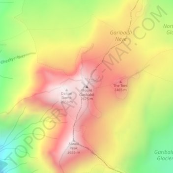
Nom : Carte topographique Mount Garibaldi, altitude, relief.
Altitude moyenne : 2.146 m
Altitude minimum : 1.528 m
Altitude maximum : 2.648 m
Faire un don
Équipez-vous pour votre prochaine aventure :
En tant que Partenaire Amazon, ce site perçoit une commission sur les achats éligibles sans surcoût pour vous.
Autres cartes topographiques
Cliquez sur une carte pour visualiser sa topographie, son altitude et son relief.
Isabel Lake
Canada > British Columbia > Fraser Valley Regional District > Area F (McConnell Creek/Hatzic Prairie)
Altitude moyenne : 687 m
Misty Icefield
Canada > British Columbia > Fraser Valley Regional District > Area F (McConnell Creek/Hatzic Prairie)
Altitude moyenne : 1.800 m
Mamquam Icefield
Canada > British Columbia > Fraser Valley Regional District > Area F (McConnell Creek/Hatzic Prairie)
Altitude moyenne : 1.925 m
Misty Icefield
Canada > British Columbia > Fraser Valley Regional District > Area F (McConnell Creek/Hatzic Prairie)
Altitude moyenne : 1.800 m
Faire un don
Équipez-vous pour votre prochaine aventure :
En tant que Partenaire Amazon, ce site perçoit une commission sur les achats éligibles sans surcoût pour vous.