
Faire un don
Équipez-vous pour votre prochaine aventure :
En tant que Partenaire Amazon, ce site perçoit une commission sur les achats éligibles sans surcoût pour vous.
Carte topographique Bella Vista
Cliquez sur la carte pour afficher l’altitude.
Faire un don
Équipez-vous pour votre prochaine aventure :
En tant que Partenaire Amazon, ce site perçoit une commission sur les achats éligibles sans surcoût pour vous.
Bella Vista
The city of Bella Vista is located on the Springfield Plateau of the Ozark Mountains. Oak/hickory forests, along with valleys, creeks, and steep rises, characterize the city's topography. Bella Vista is located north of Bentonville and Rogers within the Northwest Arkansas region. The city has been experiencing a population and building boom in recent years, as indicated by a 60% growth in population between the 2000 and 2010 censuses.
Faire un don
Équipez-vous pour votre prochaine aventure :
En tant que Partenaire Amazon, ce site perçoit une commission sur les achats éligibles sans surcoût pour vous.
À propos de cette carte
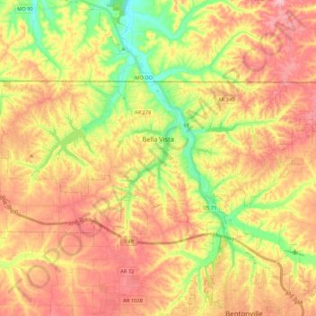
Nom : Carte topographique Bella Vista, altitude, relief.
Lieu : Bella Vista, Benton County, Arkansas, 72715, United States (36.41540 -94.37568 36.49960 -94.16197)
Altitude moyenne : 372 m
Altitude minimum : 283 m
Altitude maximum : 447 m
Faire un don
Équipez-vous pour votre prochaine aventure :
En tant que Partenaire Amazon, ce site perçoit une commission sur les achats éligibles sans surcoût pour vous.
Autres cartes topographiques
Cliquez sur une carte pour visualiser sa topographie, son altitude et son relief.
Bentonville
United States > Arkansas > Benton County > Bentonville > Bentonville
Bentonville lies in the humid subtropical climate zone (Köppen Cfa) with influence from the humid continental climate type. Bentonville experiences all four seasons and does receive cold air masses from the north, however some of the Arctic masses are blocked by the higher elevations of the Ozarks. July is…
Altitude moyenne : 383 m
Faire un don
Équipez-vous pour votre prochaine aventure :
En tant que Partenaire Amazon, ce site perçoit une commission sur les achats éligibles sans surcoût pour vous.
Faire un don
Équipez-vous pour votre prochaine aventure :
En tant que Partenaire Amazon, ce site perçoit une commission sur les achats éligibles sans surcoût pour vous.
Blowing Springs Bike & Fitness Park
United States > Arkansas > Benton County > Bella Vista
Altitude moyenne : 351 m