
Carte topographique Andaman and Nicobar Islands
Carte interactive
Cliquez sur la carte pour afficher l’altitude.
À propos de cette carte
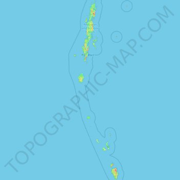
Nom : Carte topographique Andaman and Nicobar Islands, altitude, relief.
Lieu : Andaman and Nicobar Islands, India (6.75627 92.20421 13.67531 94.27732)
Altitude moyenne : 1 m
Altitude minimum : 0 m
Altitude maximum : 625 m
Autres cartes topographiques
Cliquez sur une carte pour visualiser sa topographie, son altitude et son relief.
Bengaluru
India > Karnataka > Bangalore North
Bengaluru, Bangalore North, Bengaluru Urban District, Karnataka, India
Altitude moyenne : 881 m
Chennai
India > Tamil Nadu > Chennai
Chennai, Chennai District, Tamil Nadu, India
Altitude moyenne : 8 m
3d
India > Rajasthan > Ganganagar Tehsil > 1 LNP
3d, 1 LNP, Ganganagar Tehsil, Sri Ganganagar District, Rajasthan, India
Altitude moyenne : 178 m
Bachupally mandal
Bachupally mandal, Medchal–Malkajgiri District, Telangana, 500090, India
Altitude moyenne : 593 m
Coimbatore
India > Tamil Nadu > Coimbatore North
Coimbatore, Coimbatore North, Coimbatore District, Tamil Nadu, 641001, India
Altitude moyenne : 452 m
Pune
India > Maharashtra > Pune City > Pune
Pune, Pune City, Pune District, Maharashtra, 411001, India
Altitude moyenne : 641 m
Western Ghats
Western Ghats, Idukki, Kerala, 685614, India
Altitude moyenne : 2.225 m
North Sentinel Island
India > Andaman and Nicobar Islands > Ferrargunj
North Sentinel Island, Ferrargunj, South Andaman District, Andaman and Nicobar Islands, India
Altitude moyenne : 20 m
Srinagar
India > Jammu and Kashmir > Srinagar (South)
Srinagar, Srinagar (South), Srinagar District, Jammu and Kashmir, 190001, India
Altitude moyenne : 1.805 m
Gurgaon
India > Haryana > Gurugram District
Gurgaon, Gurugram District, Haryana, India
Altitude moyenne : 237 m
Kolkata
Kolkata, Kolkata District, West Bengal, 700073, India
Altitude moyenne : 5 m
Prayagraj
India > Uttar Pradesh > Prayagraj
Prayagraj, Prayagraj District, Uttar Pradesh, 211001, India
Altitude moyenne : 91 m
Thiruvananthapuram
India > Kerala > Thiruvananthapuram
Thiruvananthapuram, Thiruvananthapuram District, Kerala, 695001, India
Altitude moyenne : 33 m
Kodaikanal
Kodaikanal, Dindigul District, Tamil Nadu, India
Altitude moyenne : 869 m
Varana
India > Gujarat > Sami Taluka
Varana, Sami Taluka, Patan District, Gujarat, India
Altitude moyenne : 32 m
Shimla
India > Himachal Pradesh > Shimla (urban)
Shimla, Shimla (urban), Shimla District, Himachal Pradesh, 171001, India
Altitude moyenne : 1.557 m
Kodia God
India > Madhya Pradesh > Narsinghgarh Tahsil
Kodia God, Narsinghgarh Tahsil, Rajgarh District, Madhya Pradesh, India
Altitude moyenne : 430 m
riyuni tal
India > Uttarakhand > Ranikhet > Majkhali
riyuni tal, Majkhali, Ranikhet, Almora District, Uttarakhand, 263652, India
Altitude moyenne : 1.567 m
Vagamon Lake
India > Kerala > Peerumade > Vagamon
Vagamon Lake, Vagamon, Peerumade, Idukki District, Kerala, India
Altitude moyenne : 976 m
Thodupuzha
India > Kerala > Thodupuzha
Thodupuzha, Idukki District, Kerala, 685584, India
Altitude moyenne : 53 m
Jakhni
India > Uttarakhand > Jakholi
Jakhni, Jakholi, Rudraprayag District, Uttarakhand, 246475, India
Altitude moyenne : 1.265 m