
Carte topographique Punjab
Carte interactive
Cliquez sur la carte pour afficher l’altitude.
À propos de cette carte
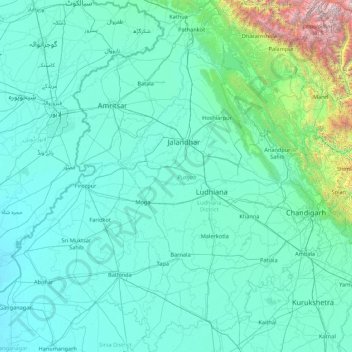
Nom : Carte topographique Punjab, altitude, relief.
Lieu : Punjab, India (29.54294 73.87983 32.51118 76.93906)
Altitude moyenne : 477 m
Altitude minimum : 170 m
Altitude maximum : 6.027 m
Punjab is in northwestern India and has a total area of 50,362 square kilometres (19,445 sq mi). Punjab is bordered by Pakistan's Punjab province on the west, Jammu and Kashmir on the north, Himachal Pradesh on the northeast and Haryana and Rajasthan on the south. Most of Punjab lies in a fertile, alluvial plain with perennial rivers and an extensive irrigation canal system. A belt of undulating hills extends along the northeastern part of the state at the foot of the Himalayas. Its average elevation is 300 metres (980 ft) above sea level, with a range from 180 metres (590 ft) in the southwest to more than 500 metres (1,600 ft) around the northeast border. The southwest of the state is semi-arid, eventually merging into the Thar Desert. Of the five Punjab rivers, three—Sutlej, Beas and Ravi—flow through the Indian state. The Sutlej and Ravi define parts of the international border with Pakistan.
Autres cartes topographiques
Cliquez sur une carte pour visualiser sa topographie, son altitude et son relief.
Bengaluru
India > Karnataka > Bangalore North
Bengaluru, Bangalore North, Bengaluru Urban District, Karnataka, India
Altitude moyenne : 881 m
Gangodanahalli
India > Karnataka > Bangalore North
Gangodanahalli, Bangalore North, Bengaluru Urban, Karnataka, 560018, India
Altitude moyenne : 865 m
Chennai
India > Tamil Nadu > Chennai
Chennai, Chennai District, Tamil Nadu, India
Altitude moyenne : 8 m
Shimla
India > Himachal Pradesh > Shimla (urban)
Shimla, Shimla (urban), Shimla District, Himachal Pradesh, 171001, India
Altitude moyenne : 1.557 m
Sheoganj
India > Rajasthan > Sheoganj Tehsil
Sheoganj, Sheoganj Tehsil, Sirohi District, Rajasthan, 306902, India
Altitude moyenne : 271 m
3d
India > Rajasthan > Ganganagar Tehsil > 1 LNP
3d, 1 LNP, Ganganagar Tehsil, Sri Ganganagar District, Rajasthan, India
Altitude moyenne : 178 m
Kodaikanal
Kodaikanal, Dindigul District, Tamil Nadu, India
Altitude moyenne : 869 m
Kachohalli
India > Karnataka > Bangalore North
Kachohalli, Bangalore North, Bengaluru Urban, Karnataka, 560018, India
Altitude moyenne : 868 m
Bhatrahalli
India > Karnataka > Kolar taluk
Bhatrahalli, Kolar taluk, Kolar District, Karnataka, India
Altitude moyenne : 825 m
Kambalipura
India > Karnataka > Anekal > Kambalipura
Kambalipura, Anekal, Bengaluru Urban, Karnataka, India
Altitude moyenne : 886 m
Hosur
India > Tamil Nadu > Hosur
Hosur, Krishnagiri District, Tamil Nadu, 635109, India
Altitude moyenne : 859 m
Karaikudi
India > Tamil Nadu > Karaikkudi
Karaikudi, Karaikkudi, Sivagangai District, Tamil Nadu, 623001, India
Altitude moyenne : 87 m
Whitefield
India > Karnataka > Bangalore East > Bengaluru
Whitefield, Bengaluru, Bangalore East, Bengaluru Urban District, Karnataka, 560066, India
Altitude moyenne : 875 m
Bachupally mandal
Bachupally mandal, Medchal–Malkajgiri District, Telangana, 500090, India
Altitude moyenne : 593 m
Coimbatore
India > Tamil Nadu > Coimbatore North
Coimbatore, Coimbatore North, Coimbatore District, Tamil Nadu, 641001, India
Altitude moyenne : 452 m
Pune
India > Maharashtra > Pune City > Pune
Pune, Pune City, Pune District, Maharashtra, 411001, India
Altitude moyenne : 641 m
North Sentinel Island
India > Andaman and Nicobar Islands > Ferrargunj
North Sentinel Island, Ferrargunj, South Andaman District, Andaman and Nicobar Islands, India
Altitude moyenne : 20 m
Gurgaon
India > Haryana > Gurugram District
Gurgaon, Gurugram District, Haryana, India
Altitude moyenne : 237 m
Western Ghats
Western Ghats, Idukki, Kerala, 685614, India
Altitude moyenne : 2.225 m
Srinagar
India > Jammu and Kashmir > Srinagar (South)
Srinagar, Srinagar (South), Srinagar District, Jammu and Kashmir, 190001, India
Altitude moyenne : 1.805 m
Prayagraj
India > Uttar Pradesh > Prayagraj
Prayagraj, Prayagraj District, Uttar Pradesh, 211001, India
Altitude moyenne : 91 m
Kolkata
Kolkata, Kolkata District, West Bengal, 700073, India
Altitude moyenne : 5 m
Kodia God
India > Madhya Pradesh > Narsinghgarh Tahsil
Kodia God, Narsinghgarh Tahsil, Rajgarh District, Madhya Pradesh, India
Altitude moyenne : 430 m
riyuni tal
India > Uttarakhand > Ranikhet > Majkhali
riyuni tal, Majkhali, Ranikhet, Almora District, Uttarakhand, 263652, India
Altitude moyenne : 1.567 m
Varana
India > Gujarat > Sami Taluka
Varana, Sami Taluka, Patan District, Gujarat, India
Altitude moyenne : 32 m
Vagamon Lake
India > Kerala > Peerumade > Vagamon
Vagamon Lake, Vagamon, Peerumade, Idukki District, Kerala, India
Altitude moyenne : 976 m
Thodupuzha
India > Kerala > Thodupuzha
Thodupuzha, Idukki District, Kerala, 685584, India
Altitude moyenne : 53 m
Jakhni
India > Uttarakhand > Jakholi
Jakhni, Jakholi, Rudraprayag District, Uttarakhand, 246475, India
Altitude moyenne : 1.265 m