
Carte topographique Murphy
Cliquez sur la carte pour afficher l’altitude.
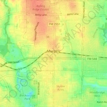
À propos de cette carte
Nom : Carte topographique Murphy, altitude, relief.
Lieu : Murphy, Collin County, Texas, 75094, United States (32.98664 -96.63280 33.04104 -96.59477)
Altitude moyenne : 169 m
Altitude minimum : 146 m
Altitude maximum : 187 m
Autres cartes topographiques
Cliquez sur une carte pour visualiser sa topographie, son altitude et son relief.
Frisco
United States > Texas > Collin County > Frisco
When the Dallas area was being settled by American pioneers, many of the settlers traveled by wagon trains along the Shawnee Trail. This trail became the Preston Trail, and later, Preston Road. With all of this activity, the community of Lebanon was founded along this trail, and was granted a U.S. post office…
Altitude moyenne : 191 m
Plano
United States > Texas > Collin County > Plano
At first, Plano's population grew slowly, reaching 1,304 in 1900 and 3,695 in 1960. By 1970, Plano began to feel some of the boom its neighbors had experienced after World War II. A series of public works projects and a change in taxes that removed the farming community from the town helped increase the…
Altitude moyenne : 181 m
Lavon Beach Estates
United States > Texas > Collin County > Lavon Beach Estates
Altitude moyenne : 154 m