
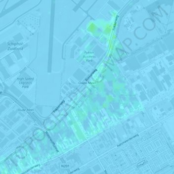
Carte topographique Oude Meer
Carte interactive
Cliquez sur la carte pour afficher l’altitude.
À propos de cette carte
Nom : Carte topographique Oude Meer, altitude, relief.
Lieu : Oude Meer, Haarlemmermeer, Noord-Holland, Nederland (52.27937 4.77011 52.29789 4.79325)
Altitude moyenne : -2 m
Altitude minimum : -8 m
Altitude maximum : 5 m
Autres cartes topographiques
Cliquez sur une carte pour visualiser sa topographie, son altitude et son relief.
Edam-Volendam
Edam-Volendam, Noord-Holland, Nederland
Altitude moyenne : -1 m
Amstelveen
Nederland > Noord-Holland > Amstelveen
Amstelveen, Noord-Holland, Nederland
Altitude moyenne : -2 m
Nieuw-Vennep
Nieuw-Vennep, Haarlemmermeer, Noord-Holland, Nederland
Altitude moyenne : -4 m
Heemskerk
Nederland > Noord-Holland > Heemskerk
Heemskerk, Noord-Holland, Nederland
Altitude moyenne : 3 m
Aalsmeer
Nederland > Noord-Holland > Aalsmeer
Aalsmeer, Noord-Holland, Nederland
Altitude moyenne : -2 m
Castricum
Nederland > Noord-Holland > Castricum
Castricum, Noord-Holland, Nederland
Altitude moyenne : 3 m
Bergen
Nederland > Noord-Holland > Bergen
Bergen, Noord-Holland, Nederland, 1861KB, Nederland
Altitude moyenne : 3 m
Santpoort-Noord
Nederland > Noord-Holland > Velsen
Santpoort-Noord, Velsen, Noord-Holland, Nederland
Altitude moyenne : 7 m
Loosdrecht
Loosdrecht, Wijdemeren, Noord-Holland, Nederland
Altitude moyenne : 0 m
Uitgeest
Nederland > Noord-Holland > Uitgeest
Uitgeest, Noord-Holland, Nederland
Altitude moyenne : -1 m
Naarden
Naarden, Gooise Meren, Noord-Holland, Nederland
Altitude moyenne : 2 m
Den Helder
Nederland > Noord-Holland > Den Helder
Den Helder, Noord-Holland, Nederland
Altitude moyenne : 0 m
Sascha Rozemarijn Meijer
Nederland > Noord-Holland > Vijfhuizen
Sascha Rozemarijn Meijer, Vijfhuizerweg, Vijfhuizen, Haarlemmermeer, Noord-Holland, Nederland, 2141 CP, Nederland
Altitude moyenne : -3 m
Hoofddorp
Hoofddorp, Haarlemmermeer, Noord-Holland, Nederland
Altitude moyenne : -3 m
Blaricum
Nederland > Noord-Holland > Blaricum
Blaricum, Noord-Holland, Nederland
Altitude moyenne : 0 m
Haarlemmermeer
Haarlemmermeer, Noord-Holland, Nederland
Altitude moyenne : 0 m
Burgerbrug
Burgerbrug, Schagen, Noord-Holland, Nederland
Altitude moyenne : 0 m
Sint Maartensbrug
Sint Maartensbrug, Schagen, Noord-Holland, Nederland
Altitude moyenne : 0 m
Zandwerven
Nederland > Noord-Holland > Spanbroek
Zandwerven, Spanbroek, Opmeer, Noord-Holland, Nederland, 1715 KM, Nederland
Altitude moyenne : -2 m
Laapersveld
Nederland > Noord-Holland > Hilversum
Laapersveld, Hilversum, Noord-Holland, Nederland
Altitude moyenne : 8 m
Beatrixpark
Nederland > Noord-Holland > Amsterdam
Beatrixpark, Zuid, Amsterdam, Noord-Holland, Nederland
Altitude moyenne : 5 m
Sijbekarspel
Sijbekarspel, Medemblik, Noord-Holland, Nederland
Altitude moyenne : -1 m
Noordeinde
Noordeinde, Alkmaar, Noord-Holland, Nederland
Altitude moyenne : -3 m
Anna Paulowna
Anna Paulowna, Hollands Kroon, Noord-Holland, Nederland
Altitude moyenne : -1 m
Broek op Langedijk
Broek op Langedijk, Dijk en Waard, Noord-Holland, Nederland
Altitude moyenne : 0 m
Zaanstreek-Waterland
Zaanstreek-Waterland, Noord-Holland, Nederland
Altitude moyenne : -1 m
Verlaat
Nederland > Noord-Holland > Oude Niedorp
Verlaat, Oude Niedorp, Hollands Kroon, Noord-Holland, Nederland, 1734 JN, Nederland
Altitude moyenne : -1 m
Julianadorp
Julianadorp, Den Helder, Noord-Holland, Nederland
Altitude moyenne : 1 m