
Carte topographique Winterthur
Carte interactive
Cliquez sur la carte pour afficher l’altitude.
À propos de cette carte
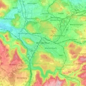
Nom : Carte topographique Winterthur, altitude, relief.
Lieu : Winterthur, Bezirk Winterthur, Zurich, Switzerland (47.44972 8.65661 47.54800 8.80994)
Altitude moyenne : 504 m
Altitude minimum : 390 m
Altitude maximum : 696 m
Winterthur is located at an elevation of 439 meters (1,440 ft). The city is located in a basin south and east of the river Töss before it meets the High Rhine after 10 kilometers. The Eulach, a small river, flows from the town's east end through the middle of the town to meet the Töss at the west exit of the city. Because of this the town is colloquially also called "Eulachstadt". Zürich lies about 20 km (12 mi) southwest of Winterthur.
Autres cartes topographiques
Cliquez sur une carte pour visualiser sa topographie, son altitude et son relief.
Ellikerbach
Switzerland > Zurich > Bezirk Winterthur > Ellikon an der Thur
Ellikerbach, Untergris, Ellikon an der Thur, Bezirk Winterthur, Zurich, 8548, Switzerland
Altitude moyenne : 400 m