
Carte topographique Ballyadam
Carte interactive
Cliquez sur la carte pour afficher l’altitude.
À propos de cette carte
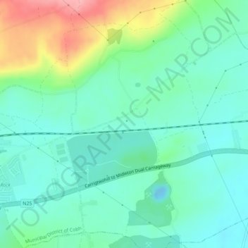
Nom : Carte topographique Ballyadam, altitude, relief.
Lieu : Ballyadam, Carrigtohill, Cobh, County Cork, Munster, Ireland (51.91170 -8.24347 51.92588 -8.22094)
Altitude moyenne : 34 m
Altitude minimum : -7 m
Altitude maximum : 124 m
Autres cartes topographiques
Cliquez sur une carte pour visualiser sa topographie, son altitude et son relief.
Cork Harbour
Cork Harbour, The Valley Road, Ballymore, Cobh Rural, Cobh, County Cork, Munster, P25A062, Ireland
Altitude moyenne : 3 m
Castleview
Castleview, Caherlag, Cobh, County Cork, Munster, T45 KW40, Ireland
Altitude moyenne : 31 m
Rushbrooke
Rushbrooke, Cobh Urban, Cobh, County Cork, Munster, T12 TW44, Ireland
Altitude moyenne : 30 m
Dromgarriff
Dromgarriff, Blackpool, Cobh, County Cork, Munster, Ireland
Altitude moyenne : 165 m