
Carte topographique Ribeira da Janela
Carte interactive
Cliquez sur la carte pour afficher l’altitude.
À propos de cette carte
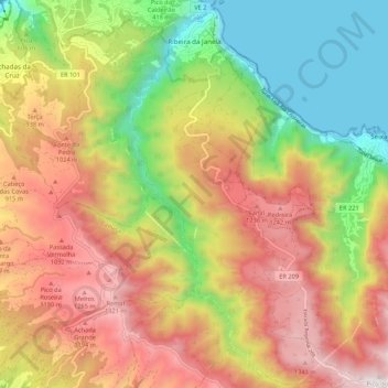
Nom : Carte topographique Ribeira da Janela, altitude, relief.
Lieu : Ribeira da Janela, Porto Moniz, Madeira, 9270, Portugal (32.76715 -17.17608 32.85736 -17.10635)
Altitude moyenne : 713 m
Altitude minimum : -1 m
Altitude maximum : 1.461 m
It is located northeast coast of the municipality of Porto Moniz, connected by the main roadway that circles the island to the principal communities in Funchal and Calheta. Mountainous, the parish is cut by several river valleys extending into the Atlantic Ocean from the interior plateau of Paul da Serra, where it borders the municipalities of Ponta do Sol and Calheta. The ravine, Ribeira da Janela, meanders through the parish from Paul da Serra (springing from the plateau at around 1,420 metres altitude) and flows at various intervals along the water course. The valley cut by this ravine is one of the longest in Madeira. Forests dominate the northern and the western parts of the valley and while brush characterises the remaining areas.
Autres cartes topographiques
Cliquez sur une carte pour visualiser sa topographie, son altitude et son relief.