
Carte topographique Highland County
Carte interactive
Cliquez sur la carte pour afficher l’altitude.
À propos de cette carte
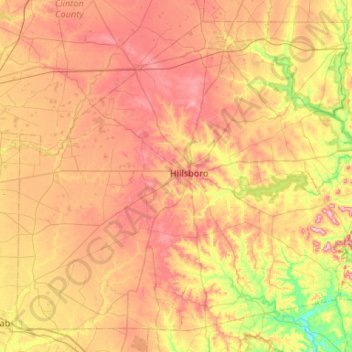
Nom : Carte topographique Highland County, altitude, relief.
Lieu : Highland County, Ohio, United States of America (39.01846 -83.87217 39.37876 -83.34395)
Altitude moyenne : 305 m
Altitude minimum : 203 m
Altitude maximum : 401 m
Highland County is a county located in the U.S. state of Ohio. As of the 2010 census, the population was 43,589. Its county seat is Hillsboro. The county is named for the topography which is hilly and divides the watersheds of the Little Miami and Scioto Rivers.
Autres cartes topographiques
Cliquez sur une carte pour visualiser sa topographie, son altitude et son relief.
Ottawa County
United States of America > Ohio
Ottawa County, Ohio, United States of America
Altitude moyenne : 180 m
East Gardens
United States of America > Ohio > Northwood > East Gardens
East Gardens, Northwood, Wood County, Ohio, 43616:43619, United States of America
Altitude moyenne : 188 m