
Carte topographique Metropolitan
Cliquez sur la carte pour afficher l’altitude.
À propos de cette carte
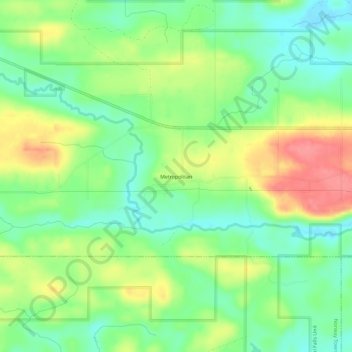
Nom : Carte topographique Metropolitan, altitude, relief.
Altitude moyenne : 371 m
Altitude minimum : 339 m
Altitude maximum : 417 m
Autres cartes topographiques
Cliquez sur une carte pour visualiser sa topographie, son altitude et son relief.
Iron Mountain
United States > Michigan > Dickinson County
Iron Mountain is included in the Marquette television market, NBC affiliate WLUC operates a local news bureau covering the city and neighboring areas. Due to distance from the transmitters and topography in the region terrestrial television signals are very limited in the area with the strongest signal coming…
Altitude moyenne : 365 m