Carte topographique Darazac
Carte interactive
Cliquez sur la carte pour afficher l’altitude.
À propos de cette carte
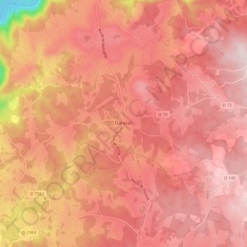
Le climat qui caractérise la commune est qualifié, en 2010, de « climat des marges montargnardes », selon la typologie des climats de la France qui compte alors huit grands types de climats en métropole. En 2020, la commune ressort du type « climat de montagne » dans la classification établie par Météo-France, qui ne compte désormais, en première approche, que cinq grands types de climats en métropole. Pour ce type de climat, la température décroît rapidement en fonction de l'altitude. On observe une nébulosité minimale en hiver et maximale en été. Les vents et les précipitations varient notablement selon le lieu.
Autres cartes topographiques
Cliquez sur une carte pour visualiser sa topographie, son altitude et son relief.
![Carte topographique Ligneyrac, altitude, relief](/pub/maps/relation/nmt/f4rs8/icon.jpg)
Ligneyrac
France > Nouvelle-Aquitaine > Corrèze
Ligneyrac, Brive-la-Gaillarde, Corrèze, Nouvelle-Aquitaine, France métropolitaine, 19500, France
Altitude moyenne : 217 m
![Carte topographique Montaignac-sur-Doustre, altitude, relief](/pub/maps/relation/k18/517lgp/icon.jpg)
Montaignac-sur-Doustre
France > Nouvelle-Aquitaine > Corrèze
Montaignac-sur-Doustre, Ussel, Corrèze, Nouvelle-Aquitaine, France métropolitaine, 19300, France
Altitude moyenne : 594 m
![Carte topographique La Nadalie, altitude, relief](/pub/maps/node/fpzs/4xt1mcdn/icon.jpg)
La Nadalie
France > Nouvelle-Aquitaine > Corrèze > Saint-Pantaléon-de-Larche
La Nadalie, Saint-Pantaléon-de-Larche, Brive-la-Gaillarde, Corrèze, Nouvelle-Aquitaine, France métropolitaine, 19600, France
Altitude moyenne : 147 m
![Carte topographique Jouix, altitude, relief](/pub/maps/node/kmb3/wmtn75zs/icon.jpg)
Jouix
France > Nouvelle-Aquitaine > Corrèze > Montaignac-sur-Doustre
Jouix, Montaignac-Saint-Hippolyte, Montaignac-sur-Doustre, Ussel, Corrèze, Nouvelle-Aquitaine, France métropolitaine, 19300, France
Altitude moyenne : 596 m
![Carte topographique Chanac-les-Mines, altitude, relief](/pub/maps/relation/cgp/2583q/icon.jpg)
Chanac-les-Mines
France > Nouvelle-Aquitaine > Corrèze
Chanac-les-Mines, Tulle, Corrèze, Nouvelle-Aquitaine, France métropolitaine, 19150, France
Altitude moyenne : 374 m
![Carte topographique Brive-la-Gaillarde, altitude, relief](/pub/maps/relation/45k/mvdmt/icon.jpg)
Brive-la-Gaillarde
France > Nouvelle-Aquitaine > Corrèze
Brive-la-Gaillarde, Corrèze, Nouvelle-Aquitaine, France métropolitaine, 19100, France
Altitude moyenne : 178 m
![Carte topographique Collonges-la-Rouge, altitude, relief](/pub/maps/relation/v18/spwz4/icon.jpg)
Collonges-la-Rouge
France > Nouvelle-Aquitaine > Corrèze
Collonges-la-Rouge, Brive-la-Gaillarde, Corrèze, Nouvelle-Aquitaine, France métropolitaine, 19500, France
Altitude moyenne : 285 m
![Carte topographique Arnac-Pompadour, altitude, relief](/pub/maps/relation/qz4/mvfgt/icon.jpg)
Arnac-Pompadour
France > Nouvelle-Aquitaine > Corrèze
Arnac-Pompadour, Brive-la-Gaillarde, Corrèze, Nouvelle-Aquitaine, France métropolitaine, 19230, France
Altitude moyenne : 369 m
![Carte topographique Saint-Aulaire, altitude, relief](/pub/maps/relation/319m/txmjdn/icon.jpg)
Saint-Aulaire
France > Nouvelle-Aquitaine > Corrèze
Saint-Aulaire, Brive-la-Gaillarde, Corrèze, Nouvelle-Aquitaine, France métropolitaine, 19130, France
Altitude moyenne : 158 m
![Carte topographique Eyrein, altitude, relief](/pub/maps/relation/4tf/xf2t6/icon.jpg)
Eyrein
France > Nouvelle-Aquitaine > Corrèze
Eyrein, Tulle, Corrèze, Nouvelle-Aquitaine, France métropolitaine, 19800, France
Altitude moyenne : 576 m
![Carte topographique Chamboulive, altitude, relief](/pub/maps/relation/ktj/wd257/icon.jpg)
Chamboulive
France > Nouvelle-Aquitaine > Corrèze
Chamboulive, Tulle, Corrèze, Nouvelle-Aquitaine, France métropolitaine, 19450, France
Altitude moyenne : 430 m
![Carte topographique Estivaux, altitude, relief](/pub/maps/relation/x35k/kkxttf/icon.jpg)
Estivaux
France > Nouvelle-Aquitaine > Corrèze
Estivaux, Brive-la-Gaillarde, Corrèze, Nouvelle-Aquitaine, France métropolitaine, 19410, France
Altitude moyenne : 340 m
![Carte topographique Palisse, altitude, relief](/pub/maps/relation/83m2/pjx3gt/icon.jpg)
Palisse
France > Nouvelle-Aquitaine > Corrèze
Palisse, Ussel, Corrèze, Nouvelle-Aquitaine, France métropolitaine, 19160, France
Altitude moyenne : 634 m
![Carte topographique Montgibaud, altitude, relief](/pub/maps/relation/f31h/rrhctj/icon.jpg)
Montgibaud
France > Nouvelle-Aquitaine > Corrèze
Montgibaud, Brive-la-Gaillarde, Corrèze, Nouvelle-Aquitaine, France métropolitaine, 19210, France
Altitude moyenne : 386 m
![Carte topographique Margerides, altitude, relief](/pub/maps/relation/32m2/83r51h/icon.jpg)
Margerides
France > Nouvelle-Aquitaine > Corrèze
Margerides, Ussel, Corrèze, Nouvelle-Aquitaine, France métropolitaine, 19200, France
Altitude moyenne : 639 m
![Carte topographique Peyrissac, altitude, relief](/pub/maps/relation/f71h/mmc3mt/icon.jpg)
Peyrissac
France > Nouvelle-Aquitaine > Corrèze
Peyrissac, Tulle, Corrèze, Nouvelle-Aquitaine, France métropolitaine, 19260, France
Altitude moyenne : 386 m
![Carte topographique Liginiac, altitude, relief](/pub/maps/relation/ggzs/hg9dgp/icon.jpg)
Liginiac
France > Nouvelle-Aquitaine > Corrèze
Liginiac, Ussel, Corrèze, Nouvelle-Aquitaine, France métropolitaine, 19160, France
Altitude moyenne : 595 m
![Carte topographique Saint-Bonnet-la-Rivière, altitude, relief](/pub/maps/relation/9d5k/mngmt/icon.jpg)
Saint-Bonnet-la-Rivière
France > Nouvelle-Aquitaine > Corrèze
Saint-Bonnet-la-Rivière, Brive-la-Gaillarde, Corrèze, Nouvelle-Aquitaine, France métropolitaine, 19130, France
Altitude moyenne : 188 m
![Carte topographique Rosiers-de-Juillac, altitude, relief](/pub/maps/relation/w5nx/41cdn/icon.jpg)
Rosiers-de-Juillac
France > Nouvelle-Aquitaine > Corrèze
Rosiers-de-Juillac, Brive-la-Gaillarde, Corrèze, Nouvelle-Aquitaine, France métropolitaine, 19350, France
Altitude moyenne : 205 m
![Carte topographique Saint-Clément, altitude, relief](/pub/maps/relation/l8tp/hkjmgp/icon.jpg)
Saint-Clément
France > Nouvelle-Aquitaine > Corrèze
Saint-Clément, Tulle, Corrèze, Nouvelle-Aquitaine, France métropolitaine, 19700, France
Altitude moyenne : 432 m
![Carte topographique Marcillac-la-Croisille, altitude, relief](/pub/maps/relation/3xtp/ttg3m2/icon.jpg)
Marcillac-la-Croisille
France > Nouvelle-Aquitaine > Corrèze
Marcillac-la-Croisille, Ussel, Corrèze, Nouvelle-Aquitaine, France métropolitaine, 19320, France
Altitude moyenne : 527 m
![Carte topographique Laurière, altitude, relief](/pub/maps/node/557/fnrc9cgt/icon.jpg)
Laurière
France > Nouvelle-Aquitaine > Corrèze > Meilhards
Laurière, Meilhards, Tulle, Corrèze, Nouvelle-Aquitaine, France métropolitaine, 19510, France
Altitude moyenne : 484 m
![Carte topographique Grandsaigne, altitude, relief](/pub/maps/relation/m57/88gggp/icon.jpg)
Grandsaigne
France > Nouvelle-Aquitaine > Corrèze
Grandsaigne, Tulle, Corrèze, Nouvelle-Aquitaine, France métropolitaine, 19300, France
Altitude moyenne : 715 m
![Carte topographique Pradines, altitude, relief](/pub/maps/relation/lkf3/ddrlb3/icon.jpg)
Pradines
France > Nouvelle-Aquitaine > Corrèze
Pradines, Tulle, Corrèze, Nouvelle-Aquitaine, France métropolitaine, 19170, France
Altitude moyenne : 762 m
![Carte topographique Bonnefond, altitude, relief](/pub/maps/relation/899m/ssjlz4/icon.jpg)
Bonnefond
France > Nouvelle-Aquitaine > Corrèze
Bonnefond, Tulle, Corrèze, Nouvelle-Aquitaine, France métropolitaine, 19170, France
Altitude moyenne : 827 m
![Carte topographique Uzerche, altitude, relief](/pub/maps/relation/68tf/g4btp/icon.jpg)
Uzerche
France > Nouvelle-Aquitaine > Corrèze
Uzerche, Tulle, Corrèze, Nouvelle-Aquitaine, France métropolitaine, 19140, France
Altitude moyenne : 371 m
![Carte topographique Lamazière-Basse, altitude, relief](/pub/maps/relation/wwb3/whnrnx/icon.jpg)
Lamazière-Basse
France > Nouvelle-Aquitaine > Corrèze
Lamazière-Basse, Ussel, Corrèze, Nouvelle-Aquitaine, France métropolitaine, 19160, France
Altitude moyenne : 570 m
![Carte topographique Saint-Viance, altitude, relief](/pub/maps/relation/fskl/d82f3/icon.jpg)
Saint-Viance
France > Nouvelle-Aquitaine > Corrèze
Saint-Viance, Brive-la-Gaillarde, Corrèze, Nouvelle-Aquitaine, France métropolitaine, 19240, France
Altitude moyenne : 135 m
![Carte topographique Peyrelevade, altitude, relief](/pub/maps/relation/pm2/h6gwdn/icon.jpg)
Peyrelevade
France > Nouvelle-Aquitaine > Corrèze
Peyrelevade, Ussel, Corrèze, Nouvelle-Aquitaine, France métropolitaine, 19290, France
Altitude moyenne : 824 m
![Carte topographique Salon-la-Tour, altitude, relief](/pub/maps/relation/dc3l/7sk4s/icon.jpg)
Salon-la-Tour
France > Nouvelle-Aquitaine > Corrèze
Salon-la-Tour, Tulle, Corrèze, Nouvelle-Aquitaine, France métropolitaine, 19510, France
Altitude moyenne : 415 m
![Carte topographique Madranges, altitude, relief](/pub/maps/relation/hnrr/rrk5tj/icon.jpg)
Madranges
France > Nouvelle-Aquitaine > Corrèze
Madranges, Tulle, Corrèze, Nouvelle-Aquitaine, France métropolitaine, 19470, France
Altitude moyenne : 563 m
![Carte topographique Gourdon-Murat, altitude, relief](/pub/maps/relation/s8nh/ggm75k/icon.jpg)
Gourdon-Murat
France > Nouvelle-Aquitaine > Corrèze
Gourdon-Murat, Tulle, Corrèze, Nouvelle-Aquitaine, France métropolitaine, 19170, France
Altitude moyenne : 756 m
![Carte topographique Lacelle, altitude, relief](/pub/maps/relation/1hcz/k785tf/icon.jpg)
Lacelle
France > Nouvelle-Aquitaine > Corrèze
Lacelle, Tulle, Corrèze, Nouvelle-Aquitaine, France métropolitaine, 19170, France
Altitude moyenne : 666 m
![Carte topographique Saint-Hilaire-les-Courbes, altitude, relief](/pub/maps/relation/svgp/66tn4s/icon.jpg)
Saint-Hilaire-les-Courbes
France > Nouvelle-Aquitaine > Corrèze
Saint-Hilaire-les-Courbes, Tulle, Corrèze, Nouvelle-Aquitaine, France métropolitaine, 19170, France
Altitude moyenne : 649 m
![Carte topographique Bugeat, altitude, relief](/pub/maps/relation/l57/fffn18/icon.jpg)
Bugeat
France > Nouvelle-Aquitaine > Corrèze
Bugeat, Ussel, Corrèze, Nouvelle-Aquitaine, France métropolitaine, 19170, France
Altitude moyenne : 739 m
![Carte topographique L'Église-aux-Bois, altitude, relief](/pub/maps/relation/wl3l/mmthgt/icon.jpg)
L'Église-aux-Bois
France > Nouvelle-Aquitaine > Corrèze
L'Église-aux-Bois, Tulle, Corrèze, Nouvelle-Aquitaine, France métropolitaine, 19170, France
Altitude moyenne : 652 m
![Carte topographique Lamongerie, altitude, relief](/pub/maps/relation/l9gp/66px4s/icon.jpg)
Lamongerie
France > Nouvelle-Aquitaine > Corrèze
Lamongerie, Tulle, Corrèze, Nouvelle-Aquitaine, France métropolitaine, 19510, France
Altitude moyenne : 439 m
![Carte topographique Saint-Augustin, altitude, relief](/pub/maps/relation/nkcz/7cttt6/icon.jpg)
Saint-Augustin
France > Nouvelle-Aquitaine > Corrèze
Saint-Augustin, Tulle, Corrèze, Nouvelle-Aquitaine, France métropolitaine, 19390, France
Altitude moyenne : 592 m
![Carte topographique Veix, altitude, relief](/pub/maps/relation/spgt/33rvnh/icon.jpg)
Veix
France > Nouvelle-Aquitaine > Corrèze
Veix, Tulle, Corrèze, Nouvelle-Aquitaine, France métropolitaine, 19260, France
Altitude moyenne : 679 m
![Carte topographique Meilhards, altitude, relief](/pub/maps/relation/k5f3/ddt9b3/icon.jpg)
Meilhards
France > Nouvelle-Aquitaine > Corrèze
Meilhards, Tulle, Corrèze, Nouvelle-Aquitaine, France métropolitaine, 19510, France
Altitude moyenne : 457 m
![Carte topographique Toy-Viam, altitude, relief](/pub/maps/relation/gzs/nnnmrr/icon.jpg)
Toy-Viam
France > Nouvelle-Aquitaine > Corrèze
Toy-Viam, Tulle, Corrèze, Nouvelle-Aquitaine, France métropolitaine, 19170, France
Altitude moyenne : 737 m
![Carte topographique La Croix, altitude, relief](/pub/maps/node/4tf/6pq6z6gp/icon.jpg)
La Croix
France > Nouvelle-Aquitaine > Corrèze > Vignols
La Croix, Vignols, Brive-la-Gaillarde, Corrèze, Nouvelle-Aquitaine, France métropolitaine, 19130, France
Altitude moyenne : 280 m
![Carte topographique Treignac, altitude, relief](/pub/maps/relation/ds14/ddt3f3/icon.jpg)
Treignac
France > Nouvelle-Aquitaine > Corrèze
Treignac, Tulle, Corrèze, Nouvelle-Aquitaine, France métropolitaine, 19260, France
Altitude moyenne : 545 m
![Carte topographique Lestards, altitude, relief](/pub/maps/relation/lbz4/88z6tp/icon.jpg)
Lestards
France > Nouvelle-Aquitaine > Corrèze
Lestards, Tulle, Corrèze, Nouvelle-Aquitaine, France métropolitaine, 19170, France
Altitude moyenne : 708 m
![Carte topographique Tarnac, altitude, relief](/pub/maps/relation/f3l/ddd3b3/icon.jpg)
Tarnac
France > Nouvelle-Aquitaine > Corrèze
Tarnac, Tulle, Corrèze, Nouvelle-Aquitaine, France métropolitaine, 19170, France
Altitude moyenne : 732 m
![Carte topographique Mont Bessou, altitude, relief](/pub/maps/node/d6gp/f453t43l/icon.jpg)
Mont Bessou
France > Nouvelle-Aquitaine > Corrèze > Meymac
Mont Bessou, Meymac, Ussel, Corrèze, Nouvelle-Aquitaine, France métropolitaine, 19250, France
Altitude moyenne : 859 m
![Carte topographique Remeniéras, altitude, relief](/pub/maps/node/3frr/ljp4ms3q/icon.jpg)
Remeniéras
France > Nouvelle-Aquitaine > Corrèze > Chamberet
Remeniéras, Chamberet, Tulle, Corrèze, Nouvelle-Aquitaine, France métropolitaine, 19370, France
Altitude moyenne : 592 m
![Carte topographique Cosnac, altitude, relief](/pub/maps/relation/p3l/68j4s/icon.jpg)
Cosnac
France > Nouvelle-Aquitaine > Corrèze > Cosnac
Cosnac, Brive-la-Gaillarde, Corrèze, Nouvelle-Aquitaine, France métropolitaine, 19360, France
Altitude moyenne : 234 m
![Carte topographique Viers, altitude, relief](/pub/maps/node/b54s/jxpkhw3l/icon.jpg)
Viers
France > Nouvelle-Aquitaine > Corrèze > Corrèze
Viers, Corrèze, Tulle, Corrèze, Nouvelle-Aquitaine, France métropolitaine, 19800, France
Altitude moyenne : 458 m
![Carte topographique Le Breuil, altitude, relief](/pub/maps/node/zh5k/f9t4t2cz/icon.jpg)
Le Breuil
France > Nouvelle-Aquitaine > Corrèze > Collonges-la-Rouge
Le Breuil, Collonges-la-Rouge, Brive-la-Gaillarde, Corrèze, Nouvelle-Aquitaine, France métropolitaine, 19500, France
Altitude moyenne : 225 m