
Faire un don
Équipez-vous pour votre prochaine aventure :
En tant que Partenaire Amazon, ce site perçoit une commission sur les achats éligibles sans surcoût pour vous.
Carte topographique Chilum
Cliquez sur la carte pour afficher l’altitude.
Faire un don
Équipez-vous pour votre prochaine aventure :
En tant que Partenaire Amazon, ce site perçoit une commission sur les achats éligibles sans surcoût pour vous.
Chilum
Chilum or Chilam is a village of Astore District in Gilgit-Baltistan, Pakistan. It is located near the junction of the Deosai Road and the Astore–Srinagar road. There is checkpost nearby, referred to as Chilam Chowki, at 35°2'8"N 75°6'10" E and elevation 3869 m (12696 ft).
Faire un don
Équipez-vous pour votre prochaine aventure :
En tant que Partenaire Amazon, ce site perçoit une commission sur les achats éligibles sans surcoût pour vous.
À propos de cette carte
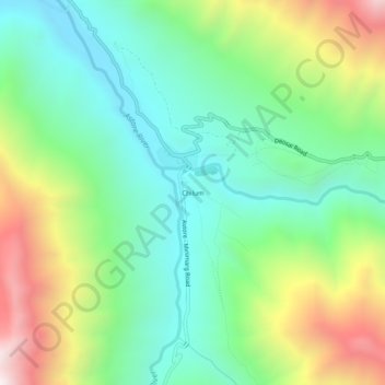
Nom : Carte topographique Chilum, altitude, relief.
Altitude moyenne : 3.702 m
Altitude minimum : 3.311 m
Altitude maximum : 4.471 m
Faire un don
Équipez-vous pour votre prochaine aventure :
En tant que Partenaire Amazon, ce site perçoit une commission sur les achats éligibles sans surcoût pour vous.
Autres cartes topographiques
Cliquez sur une carte pour visualiser sa topographie, son altitude et son relief.