
Carte topographique Klausenpass
Carte interactive
Cliquez sur la carte pour afficher l’altitude.
À propos de cette carte
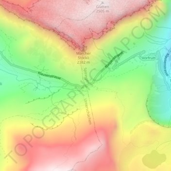
Nom : Carte topographique Klausenpass, altitude, relief.
Lieu : Klausenpass, Unterschächen, Uri, 6465, Switzerland (46.86814 8.85539 46.86824 8.85549)
Altitude moyenne : 2.103 m
Altitude minimum : 1.631 m
Altitude maximum : 2.509 m
Klausen Pass (German: Klausenpass; elevation: 1,948 metres or 6,391 feet) is a high mountain pass in the Swiss Alps connecting Altdorf in the canton of Uri with Linthal in the canton of Glarus. Somewhat unusually, the boundary between the two cantons does not lie at the summit of the pass, but some 8 kilometres (5.0 mi) down the slope towards Linthal, with the summit being in Uri.
Autres cartes topographiques
Cliquez sur une carte pour visualiser sa topographie, son altitude et son relief.
Oberalp
Switzerland > Uri > Unterschächen
Oberalp, Unterschächen, Uri, 6465, Switzerland
Altitude moyenne : 1.900 m