

Carte topographique Esher
Cliquez sur la carte pour afficher l’altitude.
Esher
Esher is an outlying suburb of London near the London-Surrey Border, and with Esher Commons at its southern end, the town marks one limit of the Greater London Built-Up Area. Esher has a linear commercial high street and is otherwise suburban in density, with varying elevations, few high rise buildings and very short sections of dual carriageway within the ward itself. Esher covers a large area, between 13 and 15.4 miles southwest of Charing Cross. In the south it is bounded by the A3 Portsmouth Road which is of urban motorway standard and buffered by the Esher Commons.
À propos de cette carte
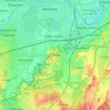
Nom : Carte topographique Esher, altitude, relief.
Lieu : Esher, Elmbridge, Surrey, England, KT10 9QU, United Kingdom (51.32939 -0.40542 51.40939 -0.32542)
Altitude moyenne : 27 m
Altitude minimum : -2 m
Altitude maximum : 88 m
Autres cartes topographiques
Cliquez sur une carte pour visualiser sa topographie, son altitude et son relief.
Cobham
United Kingdom > England > Surrey > Elmbridge
The River Mole runs through Cobham, with a visitor area and well-surfaced path by the mill in the High Street, dividing the low-rise urban village/town centre from the remaining agricultural parts of Cobham in the west and south. This can flood small, old parts of the village centre in extreme rainfall.…
Altitude moyenne : 28 m