
Faire un don
Équipez-vous pour votre prochaine aventure :
En tant que Partenaire Amazon, ce site perçoit une commission sur les achats éligibles sans surcoût pour vous.
Carte topographique Yanta
Cliquez sur la carte pour afficher l’altitude.
Faire un don
Équipez-vous pour votre prochaine aventure :
En tant que Partenaire Amazon, ce site perçoit une commission sur les achats éligibles sans surcoût pour vous.
Yanta
The village sits about 1,540 metres (5,050 ft) above sea level. The name is variously claimed to mean "God sows" or "God the sower" in Semitic, "white dove" in Syriac and "elevation" in Arabic. It has been noted that a special type of yellow marl (lake sediments) has been noticed in Yanta and the surrounding area dated to the Oxfordian. In 2001 and 2002, archaeological studies were carried out at Kamid al lawz near Yanta that unearthed a large amount of Ancient Greek pottery.
Faire un don
Équipez-vous pour votre prochaine aventure :
En tant que Partenaire Amazon, ce site perçoit une commission sur les achats éligibles sans surcoût pour vous.
À propos de cette carte
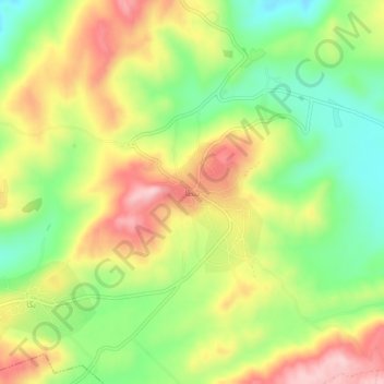
Nom : Carte topographique Yanta, altitude, relief.
Lieu : Yanta, Rashayya District, Beqaa Governorate, Lebanon (33.58413 35.92480 33.62413 35.96480)
Altitude moyenne : 1.450 m
Altitude minimum : 1.337 m
Altitude maximum : 1.579 m
Faire un don
Équipez-vous pour votre prochaine aventure :
En tant que Partenaire Amazon, ce site perçoit une commission sur les achats éligibles sans surcoût pour vous.
Autres cartes topographiques
Cliquez sur une carte pour visualiser sa topographie, son altitude et son relief.
Faire un don
Équipez-vous pour votre prochaine aventure :
En tant que Partenaire Amazon, ce site perçoit une commission sur les achats éligibles sans surcoût pour vous.
Shouf Cedar Biosphere Reserve Limit
Precipitation in the watershed is the source of both surface streamflow and groundwater. The major portion of this occurs as rain. Snowfall often occurs at the upper elevations but snow seldom persists more than a few days and disappears before the end of the rainy season. Normally snow has little overall…
Altitude moyenne : 980 m
Faire un don
Équipez-vous pour votre prochaine aventure :
En tant que Partenaire Amazon, ce site perçoit une commission sur les achats éligibles sans surcoût pour vous.
Faire un don
Équipez-vous pour votre prochaine aventure :
En tant que Partenaire Amazon, ce site perçoit une commission sur les achats éligibles sans surcoût pour vous.