
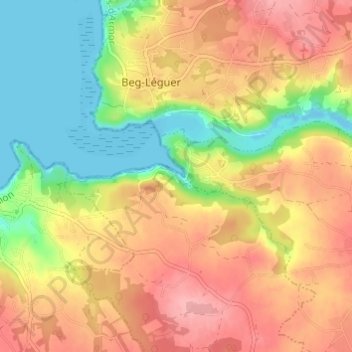
Carte topographique Pont Rous
Carte interactive
Cliquez sur la carte pour afficher l’altitude.
À propos de cette carte
Nom : Carte topographique Pont Rous, altitude, relief.
Altitude moyenne : 57 m
Altitude minimum : -9 m
Altitude maximum : 108 m
Autres cartes topographiques
Cliquez sur une carte pour visualiser sa topographie, son altitude et son relief.
Lann Kerallic
France > Bretagne > Côtes-d'Armor > Ploumilliau
Lann Kerallic, Ploumilliau, Lannion, Côtes-d'Armor, Bretagne, France métropolitaine, 22300, France
Altitude moyenne : 56 m
Lotissement Tallegas
France > Bretagne > Côtes-d'Armor > Ploumilliau
Lotissement Tallegas, Ploumilliau, Lannion, Côtes-d'Armor, Bretagne, France métropolitaine, 22300, France
Altitude moyenne : 101 m
Toull Karr
France > Bretagne > Côtes-d'Armor > Ploumilliau
Toull Karr, Ploumilliau, Lannion, Côtes-d'Armor, Bretagne, France métropolitaine, 22300, France
Altitude moyenne : 97 m
Ponchou-Meïn
France > Bretagne > Côtes-d'Armor > Ploumilliau
Ponchou-Meïn, Ploumilliau, Lannion, Côtes-d'Armor, Bretagne, France métropolitaine, 22300, France
Altitude moyenne : 85 m