
Carte topographique June Lake
Cliquez sur la carte pour afficher l’altitude.
June Lake
June Lake is a census-designated place in Mono County, California. It is located against the southern rim of the Mono Basin, 12.5 miles (20 km) south of Lee Vining, at an elevation of 7654 feet (2333 m).
À propos de cette carte
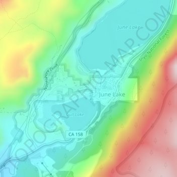
Nom : Carte topographique June Lake, altitude, relief.
Lieu : June Lake, Mono County, California, 93529, United States (37.77480 -119.08879 37.78380 -119.07132)
Altitude moyenne : 2.445 m
Altitude minimum : 2.284 m
Altitude maximum : 2.764 m
Autres cartes topographiques
Cliquez sur une carte pour visualiser sa topographie, son altitude et son relief.
June Lake
United States > California > Mono County > June Lake
Because the community is built on hills and meadows in this subalpine valley surrounded by high mountain peaks, it has been dubbed the "Switzerland of California." The area is notable for its trout fishing. Hiking is a favorite pastime of the area: June Lake offers many trails that lead into the nearby back…
Altitude moyenne : 2.531 m