
Faire un don
Équipez-vous pour votre prochaine aventure :
En tant que Partenaire Amazon, ce site perçoit une commission sur les achats éligibles sans surcoût pour vous.
Carte topographique Daviess County
Cliquez sur la carte pour afficher l’altitude.
Faire un don
Équipez-vous pour votre prochaine aventure :
En tant que Partenaire Amazon, ce site perçoit une commission sur les achats éligibles sans surcoût pour vous.
Daviess County
The terrain of Daviess County is hilly, with its area completely devoted to agriculture or urban development. Its highest elevation (740 ft; 230 m ASL) is a rise one mile (1.6 km) NNE of Farlen. The county is drained by the White River flowing to the southwest, whose two main forks (East White and West White) come together at the county's SW corner. The county's west boundary is defined by the West White River's course and its south boundary is defined by the East White River's course; their confluence defines the county's corner point.
Faire un don
Équipez-vous pour votre prochaine aventure :
En tant que Partenaire Amazon, ce site perçoit une commission sur les achats éligibles sans surcoût pour vous.
À propos de cette carte
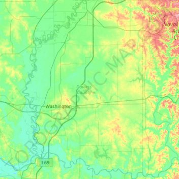
Nom : Carte topographique Daviess County, altitude, relief.
Lieu : Daviess County, Indiana, United States (38.49037 -87.27942 38.90418 -86.90423)
Altitude moyenne : 154 m
Altitude minimum : 123 m
Altitude maximum : 251 m
Faire un don
Équipez-vous pour votre prochaine aventure :
En tant que Partenaire Amazon, ce site perçoit une commission sur les achats éligibles sans surcoût pour vous.
Autres cartes topographiques
Cliquez sur une carte pour visualiser sa topographie, son altitude et son relief.
McCormick's Creek State Park
United States > Indiana > Owen County
The heart of the park is McCormick's Creek Canyon. The upper levels of the canyon are around 700 feet (210 m) above sea levels, dropping to the west fork of the White River which is near 540 feet (160 m). The McCormick's Creek waterfall is a primary attraction of the park, as Indiana has few waterfalls due to…
Altitude moyenne : 205 m
Fort Wayne
United States > Indiana > Allen County > Fort Wayne
The first settlement started in 1815. In 1819, the military garrison abandoned the fort and moved to Detroit. In 1822, a federal land office opened to sell land ceded by local Native Americans by the Treaty of St. Mary's in 1818. Platted in 1823 at the Ewing Tavern, the village became an important frontier…
Altitude moyenne : 248 m
Faire un don
Équipez-vous pour votre prochaine aventure :
En tant que Partenaire Amazon, ce site perçoit une commission sur les achats éligibles sans surcoût pour vous.