
Faire un don
Équipez-vous pour votre prochaine aventure :
En tant que Partenaire Amazon, ce site perçoit une commission sur les achats éligibles sans surcoût pour vous.
Carte topographique Tamolitch Falls
Cliquez sur la carte pour afficher l’altitude.
Faire un don
Équipez-vous pour votre prochaine aventure :
En tant que Partenaire Amazon, ce site perçoit une commission sur les achats éligibles sans surcoût pour vous.
À propos de cette carte
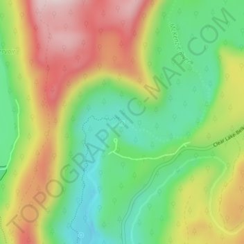
Nom : Carte topographique Tamolitch Falls, altitude, relief.
Lieu : Tamolitch Falls, Linn County, Oregon, United States (44.31222 -122.02634 44.31232 -122.02624)
Altitude moyenne : 873 m
Altitude minimum : 686 m
Altitude maximum : 1.111 m
Faire un don
Équipez-vous pour votre prochaine aventure :
En tant que Partenaire Amazon, ce site perçoit une commission sur les achats éligibles sans surcoût pour vous.
Autres cartes topographiques
Cliquez sur une carte pour visualiser sa topographie, son altitude et son relief.
Albany
United States > Oregon > Linn County
According to the United States Census Bureau, the city has a total area of 17.75 square miles (45.97 km2), of which 17.54 square miles (45.43 km2) is land and 0.21 square miles (0.54 km2) is water. Albany has 21.7 square miles (56 km2) within its urban growth boundary. Throughout the city limits and urban…
Altitude moyenne : 71 m
Faire un don
Équipez-vous pour votre prochaine aventure :
En tant que Partenaire Amazon, ce site perçoit une commission sur les achats éligibles sans surcoût pour vous.
Santiam State Forest
United States > Oregon > Linn County
Elevations in Santiam State Forest range from 1,000 to 5,000 feet (1,500 m) above sea level. The terrain is characterized by long, steep slopes leading to broad ridge tops. Stream channels are common, and in most cases, have cut deeply into the hills. Higher elevations are rocky, especially on very steep…
Altitude moyenne : 672 m
Faire un don
Équipez-vous pour votre prochaine aventure :
En tant que Partenaire Amazon, ce site perçoit une commission sur les achats éligibles sans surcoût pour vous.
Albany
United States > Oregon > Linn County
According to the United States Census Bureau, the city has a total area of 17.75 square miles (45.97 km2), of which 17.54 square miles (45.43 km2) is land and 0.21 square miles (0.54 km2) is water. Albany has 21.7 square miles (56 km2) within its urban growth boundary. Throughout the city limits and urban…
Altitude moyenne : 71 m
Faire un don
Équipez-vous pour votre prochaine aventure :
En tant que Partenaire Amazon, ce site perçoit une commission sur les achats éligibles sans surcoût pour vous.
Albany
United States > Oregon > Linn County
According to the United States Census Bureau, the city has a total area of 17.75 square miles (45.97 km2), of which 17.54 square miles (45.43 km2) is land and 0.21 square miles (0.54 km2) is water. Albany has 21.7 square miles (56 km2) within its urban growth boundary. Throughout the city limits and urban…
Altitude moyenne : 71 m