
Faire un don
Équipez-vous pour votre prochaine aventure :
En tant que Partenaire Amazon, ce site perçoit une commission sur les achats éligibles sans surcoût pour vous.
Carte topographique Crognaleto
Cliquez sur la carte pour afficher l’altitude.
Faire un don
Équipez-vous pour votre prochaine aventure :
En tant que Partenaire Amazon, ce site perçoit une commission sur les achats éligibles sans surcoût pour vous.
Crognaleto
Crognaleto is a comune and city of slightly less than 2,000 people in the Province of Teramo, central Italy. Crognaleto sits at an elevation of 1,105 metres (3,625 ft) and has its communal administrative offices in the frazione (outlying area) of Nerito. The commune of Crognaleto sits on the slopes of the Monti della Laga mountain range and extends across both the northern and the southern slopes of the Vomano Valley. It lies within the Gran Sasso e Monti della Laga National Park.
Faire un don
Équipez-vous pour votre prochaine aventure :
En tant que Partenaire Amazon, ce site perçoit une commission sur les achats éligibles sans surcoût pour vous.
À propos de cette carte
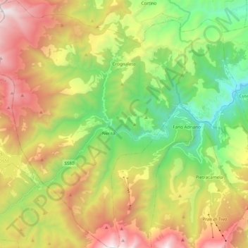
Nom : Carte topographique Crognaleto, altitude, relief.
Lieu : Crognaleto, Teramo, Abruzzo, 64043, Italy (42.48322 13.38908 42.62395 13.57659)
Altitude moyenne : 1.213 m
Altitude minimum : 328 m
Altitude maximum : 2.444 m
Faire un don
Équipez-vous pour votre prochaine aventure :
En tant que Partenaire Amazon, ce site perçoit une commission sur les achats éligibles sans surcoût pour vous.
Autres cartes topographiques
Cliquez sur une carte pour visualiser sa topographie, son altitude et son relief.
Faire un don
Équipez-vous pour votre prochaine aventure :
En tant que Partenaire Amazon, ce site perçoit une commission sur les achats éligibles sans surcoût pour vous.
Faire un don
Équipez-vous pour votre prochaine aventure :
En tant que Partenaire Amazon, ce site perçoit une commission sur les achats éligibles sans surcoût pour vous.