
Faire un don
Équipez-vous pour votre prochaine aventure :
En tant que Partenaire Amazon, ce site perçoit une commission sur les achats éligibles sans surcoût pour vous.
Carte topographique Kharan
Cliquez sur la carte pour afficher l’altitude.
Faire un don
Équipez-vous pour votre prochaine aventure :
En tant que Partenaire Amazon, ce site perçoit une commission sur les achats éligibles sans surcoût pour vous.
À propos de cette carte
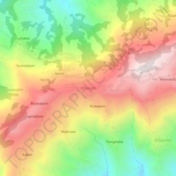
Nom : Carte topographique Kharan, altitude, relief.
Lieu : Kharan, Chainpur, Sankhuwasabha, Koshi Province, Nepal (27.25169 87.24490 27.29169 87.28490)
Altitude moyenne : 1.027 m
Altitude minimum : 512 m
Altitude maximum : 1.504 m
Faire un don
Équipez-vous pour votre prochaine aventure :
En tant que Partenaire Amazon, ce site perçoit une commission sur les achats éligibles sans surcoût pour vous.
Autres cartes topographiques
Cliquez sur une carte pour visualiser sa topographie, son altitude et son relief.
Arun River
Nepal > Koshi Province > Sankhuwasabha > Num
The Tibetan name Bum-chu may refer to a religious ceremony attempting to divine prospects for the coming year from the level of water in a pot or well, chu is the Tibetan word for water. The river originates near Gutso in Nyalam County of Tibet. Around 17 kilometres (11 mi) downstream, the Men-chu joins it.…
Altitude moyenne : 1.153 m
Faire un don
Équipez-vous pour votre prochaine aventure :
En tant que Partenaire Amazon, ce site perçoit une commission sur les achats éligibles sans surcoût pour vous.