
Carte topographique Flushing Meadows-Corona Park
Carte interactive
Cliquez sur la carte pour afficher l’altitude.
À propos de cette carte
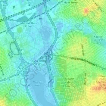
Nom : Carte topographique Flushing Meadows-Corona Park, altitude, relief.
Altitude moyenne : 10 m
Altitude minimum : -9 m
Altitude maximum : 32 m
Autres cartes topographiques
Cliquez sur une carte pour visualiser sa topographie, son altitude et son relief.
Madison Square Park
Madison Square Park, Flatiron District, Manhattan Community Board 5, Manhattan, New York County, New York, USA
Altitude moyenne : 19 m
Stephen A Rudd Playground
Stephen A Rudd Playground, Broadway Junction, Brooklyn, Kings County, New York, 11207, USA
Altitude moyenne : 24 m