
Carte topographique Ambae
Carte interactive
Cliquez sur la carte pour afficher l’altitude.
À propos de cette carte
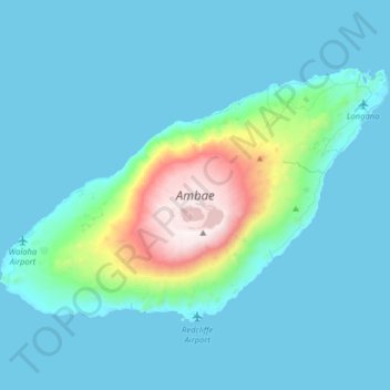
Nom : Carte topographique Ambae, altitude, relief.
Lieu : Ambae, Penama, Vanuatu (-15.47597 167.67261 -15.27453 167.99297)
Altitude moyenne : 175 m
Altitude minimum : 0 m
Altitude maximum : 1.465 m
Traditional subsistence agriculture satisfies food needs, while most villagers engage in small-scale cash crop production as well. Often grown in large upland gardens (with good rainfall and safe from roving pigs), the primary crops are taro, banana, yam, and manioc. Kumala (sweet potatoes – a good tuber thereof is called iggeremanggeggeuni), vegetables, fruits and nuts help to provide an excellent diet, though protein is occasionally lacking. Without substantial reefs, seafood is less significant a protein source compared with other islands of Vanuatu and in any case is inaccessible to the large populations living at high inland elevations.
Autres cartes topographiques
Cliquez sur une carte pour visualiser sa topographie, son altitude et son relief.
Lo-one (West Ambae)
Vanuatu > Penama > Lo-one (West Ambae)
Lo-one (West Ambae), Penama, Vanuatu
Altitude moyenne : 111 m