
Carte topographique Malaybalay
Carte interactive
Cliquez sur la carte pour afficher l’altitude.
À propos de cette carte
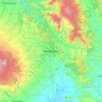
Nom : Carte topographique Malaybalay, altitude, relief.
Altitude moyenne : 822 m
Altitude minimum : 314 m
Altitude maximum : 2.151 m
The average elevation of the city is 622 metres (2,041 ft) above sea level. About 60% of the city's area has above 30% slope, characterized by steep hills, mountains, and cliff-like stream side. About 25% are level, gently sloping, and undulating. The rest are rolling and hilly.
Autres cartes topographiques
Cliquez sur une carte pour visualiser sa topographie, son altitude et son relief.
Bongbongon
Philippines > Bukidnon > Malaybalay
Bongbongon, Malaybalay, Bukidnon, Northern Mindanao, 8701, Philippines
Altitude moyenne : 693 m
Incalbog
Philippines > Bukidnon > Malaybalay
Incalbog, Malaybalay, Bukidnon, Northern Mindanao, Philippines
Altitude moyenne : 773 m
Sawaga River
Philippines > Bukidnon > Malaybalay > Casisang
Sawaga River, Casisang, Malaybalay, Bukidnon, Northern Mindanao, 8700, Philippines
Altitude moyenne : 578 m