
Carte topographique Rivière Qui Barre
Carte interactive
Cliquez sur la carte pour afficher l’altitude.
À propos de cette carte
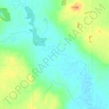
Nom : Carte topographique Rivière Qui Barre, altitude, relief.
Lieu : Rivière Qui Barre, Sturgeon County, Alberta, Canada (53.74552 -113.89084 53.75000 -113.87638)
Altitude moyenne : 679 m
Altitude minimum : 666 m
Altitude maximum : 700 m
Autres cartes topographiques
Cliquez sur une carte pour visualiser sa topographie, son altitude et son relief.
Redwater Provincial Recreation Area
Canada > Alberta > Sturgeon County
Redwater Provincial Recreation Area, Township Road 571A, Sturgeon County, Alberta, Canada
Altitude moyenne : 626 m
Hamlet of Lamoureux
Canada > Alberta > Sturgeon County
Hamlet of Lamoureux, Sturgeon County, Alberta, Canada
Altitude moyenne : 621 m
Hamlet of Rivière Qui Barre
Canada > Alberta > Sturgeon County
Hamlet of Rivière Qui Barre, Sturgeon County, Alberta, Canada
Altitude moyenne : 687 m
Hamlet of Calahoo
Canada > Alberta > Sturgeon County
Hamlet of Calahoo, Sturgeon County, Alberta, Canada
Altitude moyenne : 683 m