
Faire un don
Équipez-vous pour votre prochaine aventure :
En tant que Partenaire Amazon, ce site perçoit une commission sur les achats éligibles sans surcoût pour vous.
Carte topographique Untersberg
Cliquez sur la carte pour afficher l’altitude.
Faire un don
Équipez-vous pour votre prochaine aventure :
En tant que Partenaire Amazon, ce site perçoit une commission sur les achats éligibles sans surcoût pour vous.
Untersberg
Several trails lead to the top, though most people prefer the Untersbergbahn cable car. Constructed over a period of over two years, and opening in April 1961, the eight and a half minute journey lifts passengers from the lower terminus at the village of Sankt Leonhard at 456 m (1,496 ft) over 1,320 m (4,330 ft) to the top station on the Geiereck spur at an altitude of 1,776 m (5,827 ft), transporting them a horizontal distance of almost 2.5 km (1.6 mi) with a maximum height above the ground of 286 m (938 ft).
Faire un don
Équipez-vous pour votre prochaine aventure :
En tant que Partenaire Amazon, ce site perçoit une commission sur les achats éligibles sans surcoût pour vous.
À propos de cette carte
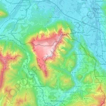
Nom : Carte topographique Untersberg, altitude, relief.
Lieu : Untersberg, Landkreis Berchtesgadener Land, Bavaria, Germany (47.62366 12.86522 47.77104 13.04785)
Altitude moyenne : 797 m
Altitude minimum : 419 m
Altitude maximum : 1.952 m
Faire un don
Équipez-vous pour votre prochaine aventure :
En tant que Partenaire Amazon, ce site perçoit une commission sur les achats éligibles sans surcoût pour vous.
Autres cartes topographiques
Cliquez sur une carte pour visualiser sa topographie, son altitude et son relief.
Obersalzberg
Germany > Bavaria > Landkreis Berchtesgadener Land > Berchtesgaden > Untersalzberg I
Altitude moyenne : 933 m
Oberjettenberg
Germany > Bavaria > Landkreis Berchtesgadener Land > Schneizlreuth
Altitude moyenne : 792 m
Mayerhofen
Germany > Bavaria > Landkreis Berchtesgadener Land > Laufen > Oberheining
Altitude moyenne : 418 m
Faire un don
Équipez-vous pour votre prochaine aventure :
En tant que Partenaire Amazon, ce site perçoit une commission sur les achats éligibles sans surcoût pour vous.
Untersalzberg I
Germany > Bavaria > Landkreis Berchtesgadener Land > Berchtesgaden
Altitude moyenne : 758 m
Laufen (Salzach)
Germany > Bavaria > Landkreis Berchtesgadener Land > Laufen > Laufen (Salzach)
Altitude moyenne : 431 m