
Carte topographique Fort Augustus
Carte interactive
Cliquez sur la carte pour afficher l’altitude.
À propos de cette carte
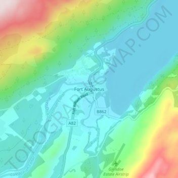
Nom : Carte topographique Fort Augustus, altitude, relief.
Lieu : Fort Augustus, Highland, Scotland, PH32 4WA, United Kingdom (57.12433 -4.70149 57.16433 -4.66149)
Altitude moyenne : 115 m
Altitude minimum : 11 m
Altitude maximum : 456 m
As with most of the British Isles and Scotland, Fort Augustus has an oceanic climate (Köppen: Cfb) with cool summers and mild winters. Like a lot of the surrounding area, sunshine levels are low at around 1,000 hours per annum and temperatures are unpredictable – Fort Augustus holds the UK's joint lowest May temperature record of −9.4 °C (15.1 °F). This is the latest point in the run up to summer that such a low temperature has been recorded, suggesting it can become a frost trap on calm clear nights due to its valley location. That same low lying topography can also give rise to some high temperatures on occasion – Fort Augustus held the UK daily high temperature record for 16 December for almost 80 years.
Autres cartes topographiques
Cliquez sur une carte pour visualiser sa topographie, son altitude et son relief.
Culloden
United Kingdom > Scotland > Highland
Culloden, Highland, Scotland, United Kingdom
Altitude moyenne : 51 m
Morar
United Kingdom > Scotland > Highland
Morar, Highland, Scotland, PH40 4PH, United Kingdom
Altitude moyenne : 30 m
Wick
United Kingdom > Scotland > Highland
Wick, Highland, Scotland, KW1 4NB, United Kingdom
Altitude moyenne : 20 m
Loch Ness
United Kingdom > Scotland > Highland > Dores
Loch Ness, Dores, Highland, Scotland, PH32 4BN, United Kingdom
Altitude moyenne : 340 m
Camore
United Kingdom > Scotland > Highland > Evelix
Camore, Evelix, Highland, Scotland, IV25 3HX, United Kingdom
Altitude moyenne : 31 m
Salen
United Kingdom > Scotland > Highland > Salen
Salen, Highland, Scotland, PH36 4JN, United Kingdom
Altitude moyenne : 83 m
Kiltarlity
United Kingdom > Scotland > Highland > Kiltarlity
Kiltarlity, Highland, Scotland, IV4 7HQ, United Kingdom
Altitude moyenne : 66 m
Fassfern
United Kingdom > Scotland > Highland > Fassfern
Fassfern, Highland, Scotland, PH33 7NP, United Kingdom
Altitude moyenne : 84 m
Nairn
United Kingdom > Scotland > Highland
Nairn, Highland, Scotland, IV12 4BW, United Kingdom
Altitude moyenne : 18 m
Kilbride
United Kingdom > Scotland > Highland
Kilbride, Highland, Scotland, IV49 9AT, United Kingdom
Altitude moyenne : 116 m
Dunvegan
United Kingdom > Scotland > Highland > Dunvegan
Dunvegan, Highland, Scotland, IV55 8WB, United Kingdom
Altitude moyenne : 41 m
Dingwall
United Kingdom > Scotland > Highland > Dingwall
Dingwall, Highland, Scotland, IV15 9RU, United Kingdom
Altitude moyenne : 94 m
Ben Nevis
United Kingdom > Scotland > Highland
Ben Nevis, Highland, Scotland, United Kingdom
Altitude moyenne : 912 m
Inverasdale
United Kingdom > Scotland > Highland
Inverasdale, Highland, Scotland, IV22 2LP, United Kingdom
Altitude moyenne : 47 m
Scottish Highlands
United Kingdom > Scotland > Highland
Scottish Highlands, Highland, Scotland, United Kingdom
Altitude moyenne : 907 m