
Faire un don
Équipez-vous pour votre prochaine aventure :
En tant que Partenaire Amazon, ce site perçoit une commission sur les achats éligibles sans surcoût pour vous.
Carte topographique Fanjingshan
Cliquez sur la carte pour afficher l’altitude.
Faire un don
Équipez-vous pour votre prochaine aventure :
En tant que Partenaire Amazon, ce site perçoit une commission sur les achats éligibles sans surcoût pour vous.
Fanjingshan
The Fanjingshan (Chinese: 梵净山; pinyin: Fànjìngshān) or Mount Fanjing, located in Tongren, Guizhou province, is the highest peak of the Wuling Mountains in southwestern China, at an elevation of 2,570 m (8,430 ft). The Fanjingshan National Nature Reserve was established in 1978 and designated a UNESCO Biosphere Reserve in 1986. Fanjingshan is a sacred mountain in Chinese Buddhism, considered to be the bodhimaṇḍa of the Maitreya Buddha. It became a UNESCO World Heritage Site in 2018.
Faire un don
Équipez-vous pour votre prochaine aventure :
En tant que Partenaire Amazon, ce site perçoit une commission sur les achats éligibles sans surcoût pour vous.
À propos de cette carte
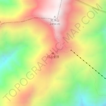
Nom : Carte topographique Fanjingshan, altitude, relief.
Altitude moyenne : 1.958 m
Altitude minimum : 1.413 m
Altitude maximum : 2.459 m
Faire un don
Équipez-vous pour votre prochaine aventure :
En tant que Partenaire Amazon, ce site perçoit une commission sur les achats éligibles sans surcoût pour vous.
Autres cartes topographiques
Cliquez sur une carte pour visualiser sa topographie, son altitude et son relief.
Faire un don
Équipez-vous pour votre prochaine aventure :
En tant que Partenaire Amazon, ce site perçoit une commission sur les achats éligibles sans surcoût pour vous.
Guiyang
Guiyang is the capital of Guizhou province in the People's Republic of China. It is centrally located within the province, on the eastern part of the Yunnan–Guizhou Plateau, and sits on the north bank of the Nanming River, a tributary of the Wu River. The city is situated at an elevation of approximately…
Altitude moyenne : 1.209 m
Faire un don
Équipez-vous pour votre prochaine aventure :
En tant que Partenaire Amazon, ce site perçoit une commission sur les achats éligibles sans surcoût pour vous.
Faire un don
Équipez-vous pour votre prochaine aventure :
En tant que Partenaire Amazon, ce site perçoit une commission sur les achats éligibles sans surcoût pour vous.
Faire un don
Équipez-vous pour votre prochaine aventure :
En tant que Partenaire Amazon, ce site perçoit une commission sur les achats éligibles sans surcoût pour vous.
Xingren
Due to its low latitude and elevation above 1,300 m (4,265.09 ft), Xingren has a monsoon-influenced humid subtropical climate (Köppen Cwa), bordering on a subtropical highland climate (Köppen Cwb) with very warm, rainy summers and mild, damp winters. The monthly 24-hour average temperature ranges from 6.6…
Altitude moyenne : 1.430 m
Faire un don
Équipez-vous pour votre prochaine aventure :
En tant que Partenaire Amazon, ce site perçoit une commission sur les achats éligibles sans surcoût pour vous.
Faire un don
Équipez-vous pour votre prochaine aventure :
En tant que Partenaire Amazon, ce site perçoit une commission sur les achats éligibles sans surcoût pour vous.
Anshun
Anshun's administrative area spans latitude 25° 21′−26° 38′ N and longitude 105° 13′−106° 34′ E and contains sizeable areas of karst formation. It borders Guiyang, the provincial capital, and Qiannan Buyei and Miao Autonomous Prefecture to the east, Liupanshui to the west, Qianxinan Buyei and…
Altitude moyenne : 1.227 m
Faire un don
Équipez-vous pour votre prochaine aventure :
En tant que Partenaire Amazon, ce site perçoit une commission sur les achats éligibles sans surcoût pour vous.