
Carte topographique Feldkahl
Cliquez sur la carte pour afficher l’altitude.
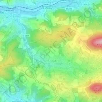
À propos de cette carte
Nom : Carte topographique Feldkahl, altitude, relief.
Lieu : Feldkahl, Hösbach, Landkreis Aschaffenburg, Bayern, Deutschland (50.03206 9.18754 50.05607 9.23808)
Altitude moyenne : 245 m
Altitude minimum : 173 m
Altitude maximum : 377 m
Autres cartes topographiques
Cliquez sur une carte pour visualiser sa topographie, son altitude et son relief.
Feldkahl
Deutschland > Bayern > Landkreis Aschaffenburg > Hösbach
Das Kirchdorf Feldkahl liegt im mittleren Kahlgrund am gleichnamigen Bach Feldkahl zwischen Rottenberg und Schimborn. Der topographisch höchste Punkt der Dorfgemarkung befindet sich an der Feldkahler Kapelle nordöstlich des Ortes am Klosterberg mit 332 m ü. NHN, der niedrigste liegt an der Feldkahl auf 193…
Altitude moyenne : 243 m
Münchhof
Deutschland > Bayern > Landkreis Aschaffenburg > Hösbach > Wenighösbach
Altitude moyenne : 216 m
Winzenhohl
Deutschland > Bayern > Landkreis Aschaffenburg > Hösbach
Das Dorf Winzenhohl liegt auf 220 m ü. NN an der Kreisstraße 2 zwischen Hösbach-Bahnhof und Haibach am Winzenhohler Bach. Der topographisch höchste Punkt der Dorfgemarkung ist der Gipfel des Kellerberges westlich des Ortes mit 330 m ü. NN, der niedrigste Punkt liegt an der Aschaff auf 147 m ü. NN. Durch…
Altitude moyenne : 228 m