
Faire un don
Équipez-vous pour votre prochaine aventure :
En tant que Partenaire Amazon, ce site perçoit une commission sur les achats éligibles sans surcoût pour vous.
Carte topographique Paskenta
Cliquez sur la carte pour afficher l’altitude.
Faire un don
Équipez-vous pour votre prochaine aventure :
En tant que Partenaire Amazon, ce site perçoit une commission sur les achats éligibles sans surcoût pour vous.
Paskenta
Paskenta (Wintun: Paskenti) is a small unincorporated town in Tehama County, California. Historically, it had greater local importance due to the presence of an active lumber mill. The ZIP Code is 96074. The community is inside area code 530 and the Paskenta CDP. Paskenta sits at an elevation of 725 feet (221 m). The 2010 United States census reported Paskenta's population was 112. Paskenta was originally inhabited by a tribe of Nomlaki people who are now part of the federally-recognized Paskenta Band of Nomlaki Indians.
Faire un don
Équipez-vous pour votre prochaine aventure :
En tant que Partenaire Amazon, ce site perçoit une commission sur les achats éligibles sans surcoût pour vous.
À propos de cette carte
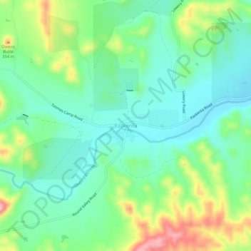
Nom : Carte topographique Paskenta, altitude, relief.
Lieu : Paskenta, Tehama County, California, 96074, United States (39.86429 -122.56697 39.90429 -122.52697)
Altitude moyenne : 268 m
Altitude minimum : 213 m
Altitude maximum : 389 m
Faire un don
Équipez-vous pour votre prochaine aventure :
En tant que Partenaire Amazon, ce site perçoit une commission sur les achats éligibles sans surcoût pour vous.
Autres cartes topographiques
Cliquez sur une carte pour visualiser sa topographie, son altitude et son relief.
Faire un don
Équipez-vous pour votre prochaine aventure :
En tant que Partenaire Amazon, ce site perçoit une commission sur les achats éligibles sans surcoût pour vous.