
Carte topographique Midland County
Carte interactive
Cliquez sur la carte pour afficher l’altitude.
À propos de cette carte
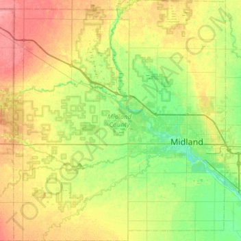
Nom : Carte topographique Midland County, altitude, relief.
Lieu : Midland County, Michigan, United States (43.46595 -84.60796 43.82848 -84.15538)
Altitude moyenne : 204 m
Altitude minimum : 180 m
Altitude maximum : 240 m
Autres cartes topographiques
Cliquez sur une carte pour visualiser sa topographie, son altitude et son relief.
Moscow Township
United States > Michigan > Hillsdale County
Moscow Township, Hillsdale County, Michigan, 49257, United States
Altitude moyenne : 348 m
Gaylord
United States > Michigan > Otsego County > Gaylord
Gaylord, Otsego County, Michigan, United States
Altitude moyenne : 401 m
Northville
United States > Michigan > Wayne County
Northville, Wayne County, Michigan, United States
Altitude moyenne : 258 m
Battle Creek
United States > Michigan > Calhoun County
Battle Creek, Calhoun County, Michigan, United States
Altitude moyenne : 274 m
Iosco Township
United States > Michigan > Livingston County
Iosco Township, Livingston County, Michigan, United States
Altitude moyenne : 282 m
Liberty Township
United States > Michigan > Wexford County
Liberty Township, Wexford County, Michigan, United States
Altitude moyenne : 313 m
Dearborn
United States > Michigan > Wayne County
Dearborn, Wayne County, Michigan, United States
Altitude moyenne : 184 m
Grand Rapids
United States > Michigan > Kent County
Grand Rapids, Kent County, Michigan, United States
Altitude moyenne : 216 m
Big Creek Township
United States > Michigan > Oscoda County
Big Creek Township, Oscoda County, Michigan, 48636, United States
Altitude moyenne : 350 m
Cheboygan County
Cheboygan County, Michigan, United States
Altitude moyenne : 222 m
Independence Charter Township
United States > Michigan > Oakland County
Independence Charter Township, Oakland County, Michigan, United States
Altitude moyenne : 318 m
Central Lake Township
United States > Michigan > Antrim County
Central Lake Township, Antrim County, Michigan, 49622, United States
Altitude moyenne : 226 m
Baltimore Township
United States > Michigan > Barry County
Baltimore Township, Barry County, Michigan, United States
Altitude moyenne : 280 m
Port Huron
United States > Michigan > Saint Clair County
Port Huron, Saint Clair County, Michigan, United States
Altitude moyenne : 185 m
Lake Orion
United States > Michigan > Oakland County
Lake Orion, Oakland County, Michigan, 48362, United States
Altitude moyenne : 303 m
Houghton
United States > Michigan > Houghton County
Houghton, Houghton County, Michigan, 49931, United States
Altitude moyenne : 269 m
Muskegon River - South Channel
United States > Michigan > Muskegon County > Muskegon
Muskegon River - South Channel, Muskegon, Muskegon Charter Township, Muskegon County, Michigan, United States
Altitude moyenne : 188 m
Bois Blanc Township
United States > Michigan > Mackinac County
Bois Blanc Township, Mackinac County, Michigan, 49775, United States
Altitude moyenne : 179 m
St. Clair River
United States > Michigan > SaintClair
St. Clair River, SaintClair, East China Township, Saint Clair County, Michigan, 48054-1596, United States
Altitude moyenne : 191 m
Brownstown Charter Township
United States > Michigan > Wayne County
Brownstown Charter Township, Wayne County, Michigan, 48134, United States
Altitude moyenne : 183 m
Elmwood Township
United States > Michigan > Tuscola County
Elmwood Township, Tuscola County, Michigan, 48735, United States
Altitude moyenne : 217 m
Charlevoix County
Charlevoix County, Michigan, United States
Altitude moyenne : 215 m
Lenawee County
Lenawee County, Michigan, United States
Altitude moyenne : 252 m
Sturgeon River
United States > Michigan > Dickinson County
Sturgeon River, Waucedah Township, Dickinson County, Michigan, United States
Altitude moyenne : 306 m
Speaker
United States > Michigan > Sanilac County
Speaker, Speaker Township, Sanilac County, Michigan, 48454, United States
Altitude moyenne : 245 m
White Lake Charter Township
United States > Michigan > Oakland County
White Lake Charter Township, Oakland County, Michigan, United States
Altitude moyenne : 303 m
Two Lakes
United States > Michigan > Alger County
Two Lakes, Munising Township, Alger County, Michigan, United States
Altitude moyenne : 219 m
Bloomfield Hills
United States > Michigan > Oakland County
Bloomfield Hills, Oakland County, Michigan, 48304, United States
Altitude moyenne : 261 m
Fife Lake Township
United States > Michigan > Grand Traverse County
Fife Lake Township, Grand Traverse County, Michigan, United States
Altitude moyenne : 318 m
Cadillac
United States > Michigan > Wexford County
Cadillac, Wexford County, Michigan, United States
Altitude moyenne : 404 m
Haynes Township
United States > Michigan > Alcona County
Haynes Township, Alcona County, Michigan, United States
Altitude moyenne : 232 m
Utica
United States > Michigan > Macomb County
Utica, Macomb County, Michigan, United States
Altitude moyenne : 197 m
Delta Charter Township
United States > Michigan > Eaton County
Delta Charter Township, Eaton County, Michigan, 48917, United States
Altitude moyenne : 263 m
Brooks Township
United States > Michigan > Newaygo County
Brooks Township, Newaygo County, Michigan, 49337, United States
Altitude moyenne : 237 m
Tower
United States > Michigan > Cheboygan County
Tower, Forest Township, Cheboygan County, Michigan, 49792, United States
Altitude moyenne : 232 m
Shelby Township
United States > Michigan > Oceana County
Shelby Township, Oceana County, Michigan, 49455, United States
Altitude moyenne : 261 m
Carp Lake Township
United States > Michigan > Emmet County
Carp Lake Township, Emmet County, Michigan, United States
Altitude moyenne : 226 m
Mackinaw City
United States > Michigan > Cheboygan County
Mackinaw City, Mackinaw Township, Cheboygan County, Michigan, 49701, United States
Altitude moyenne : 184 m
Isle Royale
United States > Michigan > Keweenaw County
Isle Royale, Keweenaw County, Michigan, United States
Altitude moyenne : 190 m
Glen Arbor Township
United States > Michigan > South Manitou Island
Glen Arbor Township, South Manitou Island, Michigan, 49636, United States
Altitude moyenne : 180 m
Mundy Charter Township
United States > Michigan > Genesee County
Mundy Charter Township, Genesee County, Michigan, United States
Altitude moyenne : 251 m
Highland Charter Township
United States > Michigan > Oakland County
Highland Charter Township, Oakland County, Michigan, 48357, United States
Altitude moyenne : 315 m
Rochester
United States > Michigan > Oakland County
Rochester, Oakland County, Michigan, United States
Altitude moyenne : 242 m
Chesterfield Charter Township
United States > Michigan > Macomb County
Chesterfield Charter Township, Macomb County, Michigan, United States
Altitude moyenne : 182 m
Mattawan
United States > Michigan > Van Buren County
Mattawan, Antwerp Township, Van Buren County, Michigan, 49071, United States
Altitude moyenne : 263 m
Troy
United States > Michigan > Oakland County
Troy, Oakland County, Michigan, United States
Altitude moyenne : 221 m
Grand Mere State Park
United States > Michigan > Berrien County > Stevensville
Grand Mere State Park, Stevensville, Lincoln Charter Township, Berrien County, Michigan, United States
Altitude moyenne : 185 m
Holmes Township
United States > Michigan > Menominee County
Holmes Township, Menominee County, Michigan, United States
Altitude moyenne : 240 m