
Carte topographique Balboa Park
Cliquez sur la carte pour afficher l’altitude.
À propos de cette carte
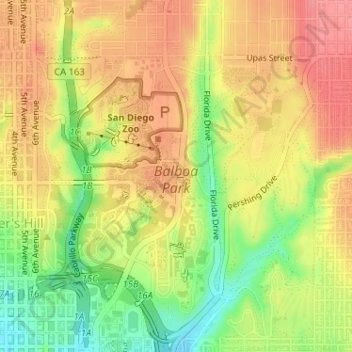
Nom : Carte topographique Balboa Park, altitude, relief.
Altitude moyenne : 73 m
Altitude minimum : 24 m
Altitude maximum : 108 m
Autres cartes topographiques
Cliquez sur une carte pour visualiser sa topographie, son altitude et son relief.
San Diego
United States > California > San Diego County > San Diego
The climate in San Diego, like most of Southern California, often varies significantly over short geographical distances, resulting in microclimates. In San Diego, this is mostly because of the city's topography (the Bay, and the numerous hills, mountains, and canyons). Frequently, particularly during the "May…
Altitude moyenne : 57 m
Lake Murray Reservoir
United States > California > San Diego County > San Diego > San Carlos
Altitude moyenne : 178 m
Rancho Peñasquitos
United States > California > San Diego County > San Diego
The highest point in the community is Black Mountain, which rises to an elevation of 1,500 feet (460 m).
Altitude moyenne : 157 m
La Jolla Shores Beach
United States > California > San Diego County > San Diego
Altitude moyenne : 39 m
Torrey Pines State Natural Reserve
United States > California > San Diego County > San Diego
Altitude moyenne : 37 m