
Carte topographique Rishton
Cliquez sur la carte pour afficher l’altitude.
Rishton
Rishton is situated in an area of low moorland north east of Blackburn and north west of Accrington. Its elevation above sea level varies from 250 feet (76 m) in the east, where Norden Brook flows into the River Hyndburn, to 785 feet (239 m) on Rishton Height, north west of the town.
À propos de cette carte
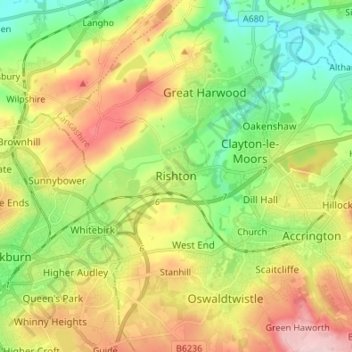
Nom : Carte topographique Rishton, altitude, relief.
Altitude moyenne : 151 m
Altitude minimum : 57 m
Altitude maximum : 283 m
Autres cartes topographiques
Cliquez sur une carte pour visualiser sa topographie, son altitude et son relief.
Oswaldtwistle Moor
United Kingdom > England > Lancashire > Hyndburn > Green Haworth > Cocker Brook
Altitude moyenne : 300 m