
Carte topographique Fishers Island
Carte interactive
Cliquez sur la carte pour afficher l’altitude.
À propos de cette carte
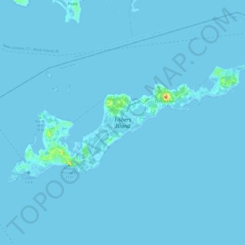
Nom : Carte topographique Fishers Island, altitude, relief.
Lieu : Fishers Island, Suffolk County, New York, United States (41.24944 -72.03866 41.29245 -71.92181)
Altitude moyenne : 1 m
Altitude minimum : -2 m
Altitude maximum : 39 m
Autres cartes topographiques
Cliquez sur une carte pour visualiser sa topographie, son altitude et son relief.
Battery Barlow (historical)
United States > New York > Suffolk County > Fishers Island > Fishers Island
Battery Barlow (historical), Fox Lane, Fishers Island, Suffolk County, New York, 06390, United States
Altitude moyenne : 1 m