
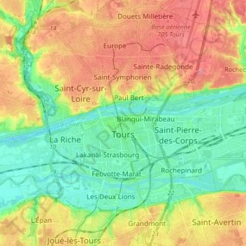
Carte topographique Tours
Carte interactive
Cliquez sur la carte pour afficher l’altitude.
À propos de cette carte
Nom : Carte topographique Tours, altitude, relief.
Altitude moyenne : 73 m
Altitude minimum : 40 m
Altitude maximum : 116 m
Tours a une altitude minimale de 44 m et une maximale de 109 m, son altitude moyenne est de 77 m tandis que celle de sa mairie est de 52 m environ.
Autres cartes topographiques
Cliquez sur une carte pour visualiser sa topographie, son altitude et son relief.
Le Bois de Plante
France > Centre-Val de Loire > Indre-et-Loire > Villandry
Le Bois de Plante, Villandry, Tours, Indre-et-Loire, Centre-Val de Loire, France métropolitaine, 37510, France
Altitude moyenne : 56 m
Montgarni
France > Centre-Val de Loire > Indre-et-Loire > Abilly
Montgarni, Abilly, Loches, Indre-et-Loire, Centre-Val de Loire, France métropolitaine, 37160, France
Altitude moyenne : 92 m
Cheillé
France > Centre-Val de Loire > Indre-et-Loire
Cheillé, Tours, Indre-et-Loire, Centre-Val de Loire, France métropolitaine, 37190, France
Altitude moyenne : 91 m
Descartes
France > Centre-Val de Loire > Indre-et-Loire
Descartes, Loches, Indre-et-Loire, Centre-Val de Loire, France métropolitaine, 37160, France
Altitude moyenne : 90 m
Le Liège
France > Centre-Val de Loire > Indre-et-Loire
Le Liège, Loches, Indre-et-Loire, Centre-Val de Loire, France métropolitaine, 37460, France
Altitude moyenne : 119 m
Luzillé
France > Centre-Val de Loire > Indre-et-Loire
Luzillé, Loches, Indre-et-Loire, Centre-Val de Loire, France métropolitaine, 37150, France
Altitude moyenne : 106 m
Draché
France > Centre-Val de Loire > Indre-et-Loire
Draché, Loches, Indre-et-Loire, Centre-Val de Loire, France métropolitaine, 37800, France
Altitude moyenne : 85 m
La Ville
France > Centre-Val de Loire > Indre-et-Loire > Sainte-Maure-de-Touraine
La Ville, Sainte-Maure-de-Touraine, Chinon, Indre-et-Loire, Centre-Val de Loire, France métropolitaine, 37800, France
Altitude moyenne : 97 m
Château
France > Centre-Val de Loire > Indre-et-Loire > Sainte-Maure-de-Touraine > La Ville
Château, Rue du Château, La Ville, Sainte-Maure-de-Touraine, Chinon, Indre-et-Loire, Centre-Val de Loire, France métropolitaine, 37800, France
Altitude moyenne : 92 m
Les Évées
France > Centre-Val de Loire > Indre-et-Loire > Saint-Martin-le-Beau
Les Évées, Saint-Martin-le-Beau, Loches, Indre-et-Loire, Centre-Val de Loire, France métropolitaine, 37270, France
Altitude moyenne : 71 m
Courçay
France > Centre-Val de Loire > Indre-et-Loire
Courçay, Loches, Indre-et-Loire, Centre-Val de Loire, France métropolitaine, 37310, France
Altitude moyenne : 87 m
Monts
France > Centre-Val de Loire > Indre-et-Loire
Monts, Tours, Indre-et-Loire, Centre-Val de Loire, France métropolitaine, 37260, France
Altitude moyenne : 81 m
Saint-Pierre-des-Corps
France > Centre-Val de Loire > Indre-et-Loire
Saint-Pierre-des-Corps, Arrondissement de Tours, Indre-et-Loire, Centre-Val de Loire, France métropolitaine, 37700, France
Altitude moyenne : 55 m
Tours
France > Centre-Val de Loire > Indre-et-Loire > Tours
Tours, Indre-et-Loire, Centre-Val de Loire, France métropolitaine, 37000, France
Altitude moyenne : 91 m
Marolle
France > Centre-Val de Loire > Indre-et-Loire > Genillé
Marolle, Genillé, Loches, Indre-et-Loire, Centre-Val de Loire, France métropolitaine, 37460, France
Altitude moyenne : 122 m
Les Quarts
France > Centre-Val de Loire > Indre-et-Loire > Montbazon
Les Quarts, Montbazon, Arrondissement de Tours, Indre-et-Loire, Centre-Val de Loire, France métropolitaine, 37250, France
Altitude moyenne : 78 m
Yzeures-sur-Creuse
France > Centre-Val de Loire > Indre-et-Loire
Yzeures-sur-Creuse, Loches, Indre-et-Loire, Centre-Val de Loire, France métropolitaine, 37290, France
Altitude moyenne : 95 m
Tour Heurtault
France > Centre-Val de Loire > Indre-et-Loire > Amboise > La Ville-Sud
Tour Heurtault, Place Michel Debré, Quai du Maréchal Joffre, La Ville-Sud, Amboise, Loches, Indre-et-Loire, Centre-Val de Loire, France métropolitaine, 37400, France
Altitude moyenne : 71 m
Cinais
France > Centre-Val de Loire > Indre-et-Loire > Cinais
Cinais, Chinon, Indre-et-Loire, Centre-Val de Loire, France métropolitaine, 37500, France
Altitude moyenne : 49 m
Loches
France > Centre-Val de Loire > Indre-et-Loire
Loches, Indre-et-Loire, Centre-Val de Loire, France métropolitaine, 37600, France
Altitude moyenne : 106 m
Vouvray
France > Centre-Val de Loire > Indre-et-Loire
Vouvray, Tours, Indre-et-Loire, Centre-Val de Loire, France métropolitaine, 37210, France
Altitude moyenne : 89 m
Richelieu
France > Centre-Val de Loire > Indre-et-Loire
Richelieu, Chinon, Indre-et-Loire, Centre-Val de Loire, France métropolitaine, 37120, France
Altitude moyenne : 62 m