
Carte topographique Valenzuela
Cliquez sur la carte pour afficher l’altitude.
Valenzuela
The highest elevation point is 38 metres (125 ft) above sea level. Having a surface gradient of 0.55% and a gentle slope, hilly landscape is located in the industrial section of the city in Canumay. The average elevation point is 2 metres (6.6 ft) above sea level.
À propos de cette carte
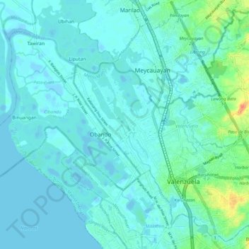
Nom : Carte topographique Valenzuela, altitude, relief.
Lieu : Valenzuela, Metro Manila, Philippines (14.66875 120.92579 14.75839 121.02459)
Altitude moyenne : 6 m
Altitude minimum : -4 m
Altitude maximum : 40 m
Autres cartes topographiques
Cliquez sur une carte pour visualiser sa topographie, son altitude et son relief.