
Carte topographique Stotfold
Carte interactive
Cliquez sur la carte pour afficher l’altitude.
À propos de cette carte
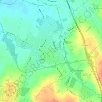
Nom : Carte topographique Stotfold, altitude, relief.
Lieu : Stotfold, Central Bedfordshire, England, United Kingdom (51.99794 -0.24543 52.03243 -0.20128)
Altitude moyenne : 54 m
Altitude minimum : 37 m
Altitude maximum : 83 m
Autres cartes topographiques
Cliquez sur une carte pour visualiser sa topographie, son altitude et son relief.
Lower Stondon
United Kingdom > England > Central Bedfordshire
Lower Stondon, Central Bedfordshire, England, SG16 6JT, United Kingdom
Altitude moyenne : 57 m
Leighton Buzzard
United Kingdom > England > Central Bedfordshire
Leighton Buzzard, Central Bedfordshire, England, LU7 1EE, United Kingdom
Altitude moyenne : 103 m
Houghton Hall Park
United Kingdom > England > Central Bedfordshire > Houghton Regis
Houghton Hall Park, Woodside Estate, Houghton Regis, Central Bedfordshire, England, LU5 5FU, United Kingdom
Altitude moyenne : 134 m
Flitton
United Kingdom > England > Central Bedfordshire
Flitton, Central Bedfordshire, England, MK45 5DY, United Kingdom
Altitude moyenne : 70 m
Blow's Downs
United Kingdom > England > Central Bedfordshire > Dunstable
Blow's Downs, Dunstable, Central Bedfordshire, England, United Kingdom
Altitude moyenne : 164 m
Haynes
United Kingdom > England > Central Bedfordshire
Haynes, Central Bedfordshire, England, United Kingdom
Altitude moyenne : 75 m
Upper Gravenhurst
United Kingdom > England > Central Bedfordshire
Upper Gravenhurst, Central Bedfordshire, England, MK45 4JF, United Kingdom
Altitude moyenne : 59 m
Edgecote
United Kingdom > England > Central Bedfordshire > Caddington > Aley Green
Edgecote, Aley Green, Caddington, Central Bedfordshire, England, LU1 4HS, United Kingdom
Altitude moyenne : 168 m
Bedfordshire
United Kingdom > England > Central Bedfordshire
Bedfordshire, Central Bedfordshire, England, United Kingdom
Altitude moyenne : 81 m
Harlington
United Kingdom > England > Central Bedfordshire
Harlington, Central Bedfordshire, England, United Kingdom
Altitude moyenne : 90 m
Sharpenhoe
United Kingdom > England > Central Bedfordshire
Sharpenhoe, Central Bedfordshire, England, MK45 4SH, United Kingdom
Altitude moyenne : 93 m
Dunstable Downs
United Kingdom > England > Central Bedfordshire > Church End
Dunstable Downs, Church End, Totternhoe, Central Bedfordshire, England, LU6 2GY, United Kingdom
Altitude moyenne : 178 m
Biggleswade
United Kingdom > England > Central Bedfordshire
Biggleswade, Central Bedfordshire, England, United Kingdom
Altitude moyenne : 37 m
Sandy
United Kingdom > England > Central Bedfordshire
Sandy, Central Bedfordshire, England, United Kingdom
Altitude moyenne : 30 m
Woburn
United Kingdom > England > Central Bedfordshire
Woburn, Central Bedfordshire, England, United Kingdom
Altitude moyenne : 131 m
Cranfield
United Kingdom > England > Central Bedfordshire
Cranfield, Central Bedfordshire, England, United Kingdom
Altitude moyenne : 88 m
Chalton
United Kingdom > England > Central Bedfordshire > Fancott
Chalton, Fancott, Central Bedfordshire, England, United Kingdom
Altitude moyenne : 124 m
Langford
United Kingdom > England > Central Bedfordshire
Langford, Central Bedfordshire, England, United Kingdom
Altitude moyenne : 40 m
Stanbridge
United Kingdom > England > Central Bedfordshire
Stanbridge, Central Bedfordshire, England, United Kingdom
Altitude moyenne : 103 m
Eversholt
United Kingdom > England > Central Bedfordshire
Eversholt, Central Bedfordshire, England, United Kingdom
Altitude moyenne : 117 m
Ampthill
United Kingdom > England > Central Bedfordshire
Ampthill, Central Bedfordshire, England, United Kingdom
Altitude moyenne : 85 m
Eggington
United Kingdom > England > Central Bedfordshire > Eggington
Eggington, Central Bedfordshire, England, United Kingdom
Altitude moyenne : 106 m
Aspley Heath
United Kingdom > England > Central Bedfordshire
Aspley Heath, Central Bedfordshire, England, United Kingdom
Altitude moyenne : 132 m
Houghton Conquest
United Kingdom > England > Central Bedfordshire
Houghton Conquest, Central Bedfordshire, England, United Kingdom
Altitude moyenne : 56 m
Stanford
United Kingdom > England > Central Bedfordshire > Stanford
Stanford, Central Bedfordshire, England, SG18 9JF, United Kingdom
Altitude moyenne : 42 m
Blunham
United Kingdom > England > Central Bedfordshire
Blunham, Central Bedfordshire, England, United Kingdom
Altitude moyenne : 24 m
Studham
United Kingdom > England > Central Bedfordshire
Studham, Central Bedfordshire, England, United Kingdom
Altitude moyenne : 173 m
Kensworth
United Kingdom > England > Central Bedfordshire
Kensworth, Central Bedfordshire, England, United Kingdom
Altitude moyenne : 181 m
Old Warden
United Kingdom > England > Central Bedfordshire
Old Warden, Central Bedfordshire, England, United Kingdom
Altitude moyenne : 48 m
Westoning
United Kingdom > England > Central Bedfordshire > Westoning
Westoning, Central Bedfordshire, England, United Kingdom
Altitude moyenne : 86 m
Gravenhurst
United Kingdom > England > Central Bedfordshire
Gravenhurst, Central Bedfordshire, England, United Kingdom
Altitude moyenne : 59 m
Brogborough
United Kingdom > England > Central Bedfordshire
Brogborough, Central Bedfordshire, England, United Kingdom
Altitude moyenne : 82 m
Tempsford
United Kingdom > England > Central Bedfordshire
Tempsford, Central Bedfordshire, England, United Kingdom
Altitude moyenne : 22 m
Milton Bryan
United Kingdom > England > Central Bedfordshire > Milton Bryan
Milton Bryan, Central Bedfordshire, England, United Kingdom
Altitude moyenne : 139 m
Slip End
United Kingdom > England > Central Bedfordshire
Slip End, Central Bedfordshire, England, United Kingdom
Altitude moyenne : 160 m
Hockliffe
United Kingdom > England > Central Bedfordshire
Hockliffe, Central Bedfordshire, England, United Kingdom
Altitude moyenne : 116 m
Edworth
United Kingdom > England > Central Bedfordshire > Edworth
Edworth, Central Bedfordshire, England, United Kingdom
Altitude moyenne : 48 m
Potsgrove
United Kingdom > England > Central Bedfordshire > Potsgrove
Potsgrove, Central Bedfordshire, England, United Kingdom
Altitude moyenne : 136 m
Northill
United Kingdom > England > Central Bedfordshire
Northill, Central Bedfordshire, England, United Kingdom
Altitude moyenne : 37 m
Barton-le-Clay
United Kingdom > England > Central Bedfordshire
Barton-le-Clay, Central Bedfordshire, England, United Kingdom
Altitude moyenne : 93 m
Husborne Crawley
United Kingdom > England > Central Bedfordshire > Husborne Crawley
Husborne Crawley, Central Bedfordshire, England, United Kingdom
Altitude moyenne : 97 m
Wrestlingworth and Cockayne Hatley
United Kingdom > England > Central Bedfordshire
Wrestlingworth and Cockayne Hatley, Central Bedfordshire, England, United Kingdom
Altitude moyenne : 51 m
Tilsworth
United Kingdom > England > Central Bedfordshire > Tilsworth
Tilsworth, Central Bedfordshire, England, United Kingdom
Altitude moyenne : 108 m
Sundon
United Kingdom > England > Central Bedfordshire
Sundon, Central Bedfordshire, England, United Kingdom
Altitude moyenne : 138 m
Tingrith
United Kingdom > England > Central Bedfordshire > Tingrith
Tingrith, Central Bedfordshire, England, United Kingdom
Altitude moyenne : 94 m
Sutton
United Kingdom > England > Central Bedfordshire > Sutton
Sutton, Central Bedfordshire, England, United Kingdom
Altitude moyenne : 40 m
Eyeworth
United Kingdom > England > Central Bedfordshire > Eyeworth
Eyeworth, Central Bedfordshire, England, United Kingdom
Altitude moyenne : 36 m
Southill
United Kingdom > England > Central Bedfordshire
Southill, Central Bedfordshire, England, United Kingdom
Altitude moyenne : 50 m
Pulloxhill
United Kingdom > England > Central Bedfordshire > Pulloxhill
Pulloxhill, Central Bedfordshire, England, United Kingdom
Altitude moyenne : 75 m
Heath and Reach
United Kingdom > England > Central Bedfordshire
Heath and Reach, Central Bedfordshire, England, United Kingdom
Altitude moyenne : 120 m